
Dataja:Extensió del valencià al País Valencià.svg

Größe der PNG-Vorschau dieser SVG-Datei: 424 × 600 pikselow. Druge rozeznaśa: 170 × 240 pikselow | 339 × 480 pikselow | 543 × 768 pikselow | 724 × 1.024 pikselow | 1.448 × 2.048 pikselow | 744 × 1.052 pikselow.
Originalna dataja (dataja SVG, nominalnje: 744 × 1.052 piksele, wjelikosć dataje: 962 kB)
Zespominanje
| Beschreibung |
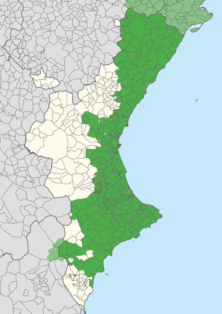
English: Extension of the Valencian language in the Valencian Community, according to Casanova and Sanchis Guarner.
Español: Extensión del Valenciano en la Comunidad Valenciana. |
| Legenda |
Català:
#4daf4a #88c286 #b7ddaa Zones English:
#4daf4a #88c286 #b7ddaa Spanish-speaking Español: #4daf4a #88c286 #b7ddaa Zonas |
| Datum | |
| Žrědło | Carche.map and OpenStreetMap. |
| Tworićel | |
| Kartografische Angaben | |
| Maßstab | 1:1.500.000 |
| Orientierung |
 |
| Georeferenzierung | If inappropriate please set warp_status = skip to hide. |
| Druge wersije toś teje dataje |
Derivative works of this file: |
| SVG‑Erstellung | |
Licencěrowanje
| This work contains information from OpenStreetMap, which is made available under the Open Database License (ODbL).
The ODbL does not require any particular license for maps produced from ODbL data. Prior to 1 August 2020, map tiles produced by the OpenStreetMap Foundation were licensed under the CC-BY-SA-2.0 license. Maps produced by other people may be subject to other licences. |
Toś ta dataja jo pód licencu Creative Commons Attribution-Share Alike 2.5 Generic licencěrowana
Pśipokazanje: Joan M. Borràs (ebrenc)
- Smějoš:
- gromaźe wužywaś – źěło kopěrowaś, rozšyriś a dalej daś
- změšaś – aby źěło pśiměrił
- Pód slědujucymi wuměnjenjami:
- pśipokazanje – Musyš źěło pó wašni pśipokazaś, kótaruž awtor abo licencowaŕ jo pódał (ale nic pó wašni, až by se gódało, až wón tebje abo twójo wužywanje źěła schwalijo).
- źěliś – Jolic měnjaš, pśetworjaš toś to źěło abo na njo natwarjaš, móžoš gótowe źěło jano pód teju sameju licencu ako toś ta rozšyriś.
Stawizny dataje
Tłoc na datum/cas aby tencasna wersija se lodowała.
| datum/cas | Pśeglědowy wobraz | rozměry | Wužywaŕ | Komentar | |
|---|---|---|---|---|---|
| něntejšny | 21. apryla 2020, 13:27 | | 744x1.052 (962 kB) | FogueraC | voltants |
| 20. apryla 2020, 18:24 |  | 744x1.052 (881 kB) | FogueraC | standard colors | |
| 18. maja 2007, 03:12 |  | 725x1.244 (1,53 MB) | Ebrenc | {{Cc-by-sa-2.5|Joan M. Borràs (ebrenc)}} Category:Maps of the Land of Valencia Category:Catalan language |
Datajowe wužywanje
Žedne boki njewótkazuju na toś tu dataju.
Globalne wužywanje datajow
Slědujuce druge wikije wužywaju toś ten wobraz:
- Wužywanje na ar.wikipedia.org
- Wužywanje na ast.wikipedia.org
- Wužywanje na ca.wikipedia.org
- Wužywanje na co.wikipedia.org
- Wužywanje na cs.wikipedia.org
- Wužywanje na de.wikipedia.org
- Wužywanje na en.wikipedia.org
- Wužywanje na es.wikipedia.org
- Comunidad Valenciana
- Discusión:Idiomas de España
- Vega Baja del Segura
- Predominio lingüístico
- Ley de uso y enseñanza del valenciano
- Portal:Comunidad Valenciana
- Idioma valenciano
- Usuario:Castellónenred/Página de Pruebas/PortalCV/Cultura y Tradiciones
- Portal:Comunidad Valenciana/Cultura y Tradiciones
- Cultura de la Comunidad Valenciana
- Usuario:MetroVal/Valenciano
- Usuario:JuananMJ/Taller
- Wužywanje na es.wikivoyage.org
- Wužywanje na eu.wikipedia.org
- Wužywanje na ext.wikipedia.org
- Wužywanje na fi.wikipedia.org
- Wužywanje na fr.wikipedia.org
- Wužywanje na gl.wikipedia.org
- Wužywanje na he.wikipedia.org
- Wužywanje na ia.wikipedia.org
- Wužywanje na id.wikipedia.org
- Wužywanje na ie.wikipedia.org
- Wužywanje na it.wikipedia.org
- Wužywanje na ja.wikipedia.org
Dalšne globalne wužywanje toś teje dataje pokazaś.