
Dataja:11-09-fotofluege-cux-allg-25a.jpg

Wjelikosć toś togo pśeglěda: 600 × 600 pikselow. Druge rozeznaśa: 240 × 240 pikselow | 480 × 480 pikselow | 768 × 768 pikselow | 1.024 × 1.024 pikselow | 2.048 × 2.048 pikselow | 2.848 × 2.848 pikselow.
Originalna dataja (2.848 × 2.848 pikselow, wjelikosć dataje: 5,53 MB, MIME-Typ: image/jpeg)
Zespominanje
| wopis |
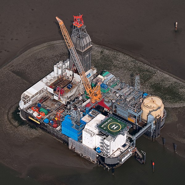
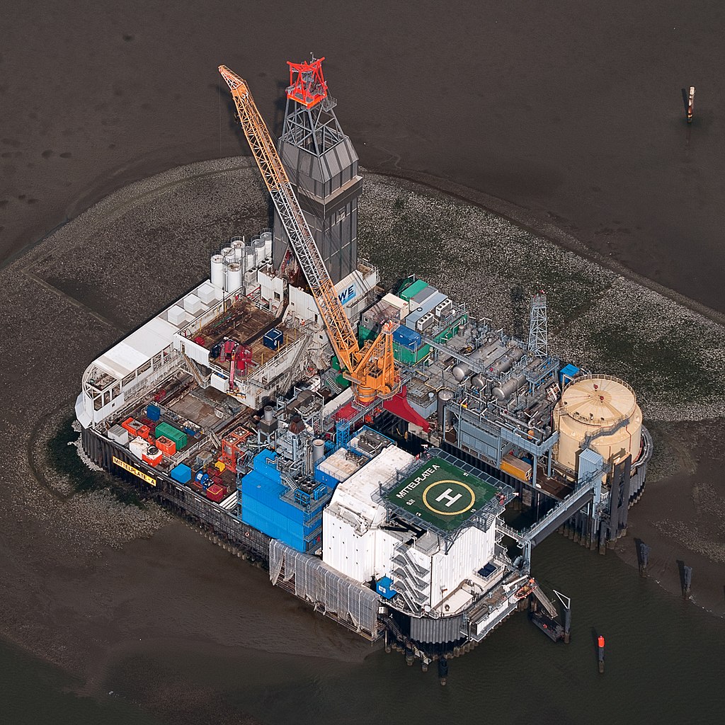
Deutsch: Fotoflug Nordsee; Ölbohrinsel im Ölfeld Mittelplate
English: Germany’s largest oil field Mittelplate
Español: Vista aérea de la plataforma petrolera de Mittelplate, el mayor yacimiento petrolífero de Alemania.
Français : Vue aérienne de Mittelplate, le plus grand champ pétrolifère d'Allemagne
Polski: Platforma wiertnicza na największym niemieckim polu naftowym „Mittelplate” znajdującym się na Morzu Północnym.
Português: Vista aérea da plataforma petrolífera de Mittelplate, o maior campo de petróleo da Alemanha. |
|||||||||||||||||||||||
| Datum | ||||||||||||||||||||||||
| Žrědło | Swójske źěło | |||||||||||||||||||||||
| Awtor |
|
|||||||||||||||||||||||
| Dowolenje (dalewužiwanje tuteje dataje) |
|
|||||||||||||||||||||||
| Druge wersije toś teje dataje |
 |
|||||||||||||||||||||||

| Pozicija kamery | | Tónle a dalše wobrazy pola: OpenStreetMap |
|---|
Auszeichnungen
|
This image was selected as picture of the day on Wikimedia Commons for 2 February 2016. It was captioned as follows: English: Germany’s largest oil field Mittelplate Other languages:
Bosanski: Najveće naftno polje u Njemačkoj, Mittelplate Català: Mittelplate, el camp petrolier més gran d'Alemanya. Deutsch: Fotoflug Nordsee; Ölbohrinsel im Ölfeld Mittelplate English: Germany’s largest oil field Mittelplate Español: Vista aérea de la plataforma petrolera de Mittelplate, el mayor yacimiento petrolífero de Alemania. Italiano: Vista aerea della piattaforma petrolifera di Mittelplate, il principale giacimento petrolifero tedesco. Português: Vista aérea da plataforma petrolífera de Mittelplate, o maior campo de petróleo da Alemanha. Suomi: Mittelplate, suurin öljykentän Saksan. Македонски: Мителплате — најголемото нафтено поле во Германија. Русский: Миттельплате, крупнейшее месторождение нефти Германии. 한국어: 독일에서 가장 큰 유전 미텔플라테. 中文: 德国最大油井 Mittelplate 中文(繁體): 德國最大油井 Mittelplate |
Licencěrowanje
| Dieses Foto entstand aufgrund eines Projektes, das von Wikimedia Deutschland e. V. gefördert wurde.
Im Rahmen des „Community-Projektbudgets“ sollen Luftbilder u.a. von Inseln, Halligen, Sanden und Küstenorten der deutschen Nordseeküste angefertigt werden. Das Projekt „Fotoflüge“ wurde im September 2011 begonnen. |
Diese Datei ist unter der Creative-Commons-Lizenz „Namensnennung – Weitergabe unter gleichen Bedingungen 3.0 Deutschland“ lizenziert.
- Smějoš:
- gromaźe wužywaś – źěło kopěrowaś, rozšyriś a dalej daś
- změšaś – aby źěło pśiměrił
- Pód slědujucymi wuměnjenjami:
- pśipokazanje – Musyš źěło pó wašni pśipokazaś, kótaruž awtor abo licencowaŕ jo pódał (ale nic pó wašni, až by se gódało, až wón tebje abo twójo wužywanje źěła schwalijo).
- źěliś – Jolic měnjaš, pśetworjaš toś to źěło abo na njo natwarjaš, móžoš gótowe źěło jano pód teju sameju licencu ako toś ta rozšyriś.

Stawizny dataje
Tłoc na datum/cas aby tencasna wersija se lodowała.
| datum/cas | Pśeglědowy wobraz | rozměry | Wužywaŕ | Komentar | |
|---|---|---|---|---|---|
| něntejšny | 13. januara 2015, 22:40 | | 2.848x2.848 (5,53 MB) | Ralf Roletschek | volle Auflösung aus Original |
| 28. februara 2013, 19:13 |  | 2.848x2.848 (3,94 MB) | Jkadavoor | Reverted to version as of 21:23, 4 September 2011 per Commons:Overwriting_existing_files#DO_NOT_overwrite : Files that have been awarded a special status like Commons Featured Picture, or similar status on another Wikimedia project. Such files are ... | |
| 21. februara 2013, 17:32 |  | 5.932x5.932 (14,62 MB) | Ralf Roletschek | größere Version | |
| 4. septembra 2011, 23:23 |  | 2.848x2.848 (3,94 MB) | Ralf Roletschek | {{Information |Description=Fotoflug Nordsee |Source={{own}} |Date=2011-09-04 |Author=Ralf Roletschek (<span class="signature-talk">talk</span>) |Permission= |other_versions=[[File:11-09-fotofluege-cux |
Datajowe wužywanje
Žedne boki njewótkazuju na toś tu dataju.
Globalne wužywanje datajow
Slědujuce druge wikije wužywaju toś ten wobraz:
- Wužywanje na ar.wikipedia.org
- Wužywanje na ar.wikinews.org
- Wužywanje na be-tarask.wikipedia.org
- Wužywanje na bg.wikipedia.org
- Wužywanje na ca.wikipedia.org
- Wužywanje na ceb.wikipedia.org
- Wužywanje na crh.wikipedia.org
- Wužywanje na cs.wikipedia.org
- Wužywanje na cv.wikipedia.org
- Wužywanje na da.wikipedia.org
- Wužywanje na de.wikipedia.org
- Wattenmeer (Nordsee)
- Erdöl
- Luftbildfotografie
- Bohrinsel
- Erdölförderung in Deutschland
- Mittelplate (Ölfeld)
- Friedrichskoog
- Nordseeöl
- Recht am Bild der eigenen Sache
- Wikipedia:Projekt Fotoflüge/2011/September
- Wikipedia:Projekt Fotoflüge/Ergebnisse
- Wikipedia Diskussion:Projekt Fotoflugkurs Cuxhaven 2013
- Wikipedia:AdminConvention 2016/Teilnehmer
- Benutzer:Artikelstube/Liste von Bauverfahren
- Wužywanje na de.wikiversity.org
- Wužywanje na de.wikivoyage.org
- Wužywanje na el.wikipedia.org
- Wužywanje na en.wikipedia.org
- Oil platform
- North Sea oil
- Wikipedia:WikiProject Energy
- Mittelplate
- Wikipedia:Featured pictures/Places/Architecture
- Marine architecture
- User talk:Ralf Roletschek
- User talk:Nikhil B
- Wikipedia:WikiProject Energy/Recognized content
- Portal:Energy/Explore/Recognized content
- Accommodation platform
- Wikipedia:Featured pictures thumbs/59
- Wikipedia:Featured picture candidates/November-2016
- Wikipedia:Featured picture candidates/Mittelplate
- Wikipedia:Wikipedia Signpost/2016-11-26/Featured content
- Wikipedia:Wikipedia Signpost/Single/2016-11-26
Dalšne globalne wužywanje toś teje dataje pokazaś.