
Dataja:Saarland location map.svg

Größe der PNG-Vorschau dieser SVG-Datei: 658 × 540 pikselow. Druge rozeznaśa: 293 × 240 pikselow | 585 × 480 pikselow | 936 × 768 pikselow | 1.248 × 1.024 pikselow | 2.496 × 2.048 pikselow.
Originalna dataja (dataja SVG, nominalnje: 658 × 540 piksele, wjelikosć dataje: 45 kB)
Zespominanje
| wopis |
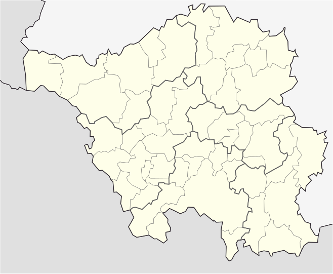
English: Position map of the state of Saarland with the six disticts and fiftytwo municipalities
Geographic limits of the map: * N: 49.65° N * S: 49.09° N * W: 6.3° E * E: 7.405° E Deutsch: Positionskarte vom Bundesland Saarland mit seinen sechs Kreisen und 52 Gemeinden Quadratische Plattkarte. Geographische Begrenzung der Karte: * N: 49.65° N * S: 49.09° N * W: 6.3° E * E: 7.405° E |
| Datum | |
| Žrědło | Swójske źěło |
| Awtor | Lantus |
| Druge wersije toś teje dataje |
|


Licencěrowanje
Ja, awtor tutoho dźěła, wozjewjam je z tym pod slědowacej licencu:
Toś ta dataja jo pód licencu Creative Commons Attribution-Share Alike 3.0 Unported licencěrowana
- Smějoš:
- gromaźe wužywaś – źěło kopěrowaś, rozšyriś a dalej daś
- změšaś – aby źěło pśiměrił
- Pód slědujucymi wuměnjenjami:
- pśipokazanje – Musyš źěło pó wašni pśipokazaś, kótaruž awtor abo licencowaŕ jo pódał (ale nic pó wašni, až by se gódało, až wón tebje abo twójo wužywanje źěła schwalijo).
- źěliś – Jolic měnjaš, pśetworjaš toś to źěło abo na njo natwarjaš, móžoš gótowe źěło jano pód teju sameju licencu ako toś ta rozšyriś.
Stawizny dataje
Tłoc na datum/cas aby tencasna wersija se lodowała.
| datum/cas | Pśeglědowy wobraz | rozměry | Wužywaŕ | Komentar | |
|---|---|---|---|---|---|
| něntejšny | 25. julija 2008, 03:25 | | 658x540 (45 kB) | Chumwa | etwas dezentere Grenzlinien, Rahmen entfernt, Farbanpassung Rheinland-Pfalz (da selbe administrative Ebene wie Saarland) |
| 5. julija 2008, 19:34 |  | 826x679 (39 kB) | Lantus | Position map of the state of Saarland with the six disticts and fitytwo municipalities Equirectangular projection. Geographic limits of the map: * N: 49.65° N * S: 49.09° N * W: 6.3° E * E: 7.405° E Positionskarte vom Bundesland Saarl | |
| 5. julija 2008, 19:18 |  | 826x679 (39 kB) | Lantus | {{Information |Description={{en|1=Position map of the state of Saarland with the six disticts and fitytwo municipalities}} {{de|1=Positionskarte vom Bundesland Saarland mit seinen sechs Kreisen und 52 Gemeinden}} |Source=Eigenes Werk (own work) |Author=[[ |
Datajowe wužywanje
Slědujucej 2 boka wótkazujotej na toś tu dataju:
Globalne wužywanje datajow
Slědujuce druge wikije wužywaju toś ten wobraz:
- Wužywanje na ba.wikipedia.org
- Wužywanje na cs.wikipedia.org
- Wužywanje na da.wikipedia.org
- Wužywanje na de.wikipedia.org
- Wužywanje na es.wikipedia.org
- Wužywanje na gl.wikipedia.org
- Wužywanje na hy.wikipedia.org
- Wužywanje na ro.wikipedia.org
- Wužywanje na ru.wikipedia.org
- Саарбрюккен
- Зарлуи
- Беккинген
- Нонвайлер
- Энсдорф (Саар)
- Перль (Саар)
- Марпинген
- Лебах
- Вадерн
- Зульцбах (Саар)
- Шпизен-Эльферсберг
- Швальбах (Саар)
- Метлах
- Санкт-Вендель
- Толай (община)
- Пютлинген
- Диллинген (Саар)
- Нофельден
- Фридрихсталь (Саар)
- Намборн
- Квиршид
- Релинген-Зирсбург
- Иберхерн
- Зарвеллинген
- Фёльклинген
- Мерхвайлер
- Бус (Саар)
- Хомбург (Саар)
- Санкт-Ингберт
- Валлерфанген
- Нойнкирхен (Саар)
- Лосхайм-ам-Зе
- Отвайлер
- Мерциг
- Киркель
- Вадгассен
- Хойсвайлер
- Клайнблиттерсдорф
- Блискастель
- Ригельсберг
- Мандельбахталь
Dalšne globalne wužywanje toś teje dataje pokazaś.