
Dataja:Mediterranean Sea political map-fr.svg

Größe der PNG-Vorschau dieser SVG-Datei: 800 × 585 pikselow. Druge rozeznaśa: 320 × 234 pikselow | 640 × 468 pikselow | 1.024 × 749 pikselow | 1.280 × 936 pikselow | 2.560 × 1.872 pikselow | 2.046 × 1.496 pikselow.
Originalna dataja (dataja SVG, nominalnje: 2.046 × 1.496 piksele, wjelikosć dataje: 1,1 MB)
Zespominanje
| wopis |
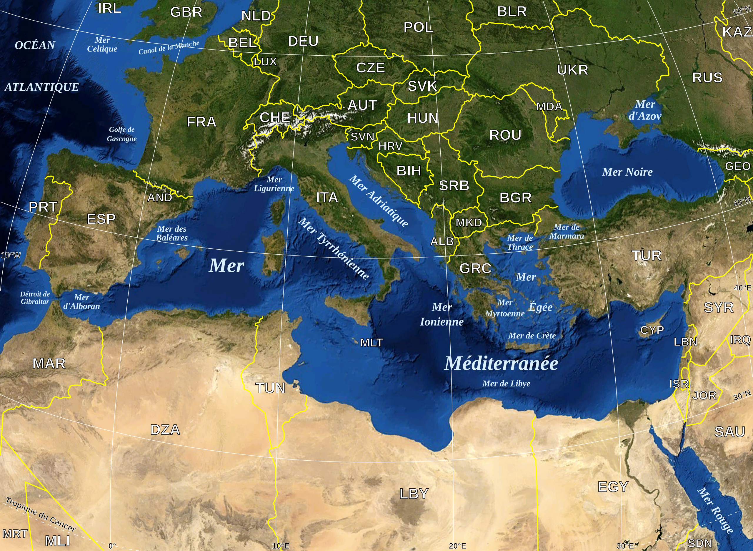
English: Map in French of the Mediterranean Sea, with the borders and the name of the States (except Montenegro, missing) following the ISO 3166-1 Alpha-3 code.
Français : Carte en français de la Mer Méditerranée avec les frontières et les noms des États (manque le Monténégro) suivant le code ISO 3166-1 Alpha-3.
Español: Mapa en francés del Mar Mediterráneo con las fronteras y los códigos de los Estados (menos el Montenegro) segun la norma ISO 3166-1 Alpha-3.
Deutsch: Karte des Mittelmeer, mit Staaten (bis auf Montenegro), ISO 3166-1 Alpha-3 code, und Grenzen, in französisch. |
| Datum | |
| Žrědło |
Own work ; Raster background map : screenshot from NASA World Wind (Public Domain) |
| Awtor | Eric Gaba (Sting - fr:Sting) |
| Dowolenje (dalewužiwanje tuteje dataje) |
All rights released |
| Druge wersije toś teje dataje |
|
| SVG‑Erstellung |


|
This SVG file contains embedded text that can be translated into your language, using any capable SVG editor, text editor or the SVG Translate tool. For more information see: About translating SVG files. |
Licencěrowanje
| Diese Datei ist gemeinfrei (Public Domain), da es sich um einen Screenshot der NASA-Software World Wind handelt, in der ein gemeinfreier Datensatz wie Blue Marble, MODIS, Landsat, SRTM, USGS oder GLOBE verwendet wird.
|
 |
| This work was previously under Public Domain, or a Free License. It has been digitally enhanced and/or modified. This derivative work has been (or is hereby) released into the public domain by its author, Sting at the French Wikipedia project. This applies worldwide. In some countries this is not legally possible; if so:
|
Stawizny dataje
Tłoc na datum/cas aby tencasna wersija se lodowała.
| datum/cas | Pśeglědowy wobraz | rozměry | Wužywaŕ | Komentar | |
|---|---|---|---|---|---|
| něntejšny | 19. maja 2008, 18:11 | | 2.046x1.496 (1,1 MB) | Sting | "Tropic of Cancer" label correction |
| 21. junija 2007, 02:56 |  | 2.046x1.496 (1,09 MB) | Sting | {{Information |Description=Map in French of the Mediterranean Sea, with the borders and the name of the States following the ISO 3166-1 Alpha-3 code. |Source=Own work ;<br/>Background map : screenshot from NASA World Wind (Public |
Datajowe wužywanje
Žedne boki njewótkazuju na toś tu dataju.
Globalne wužywanje datajow
Slědujuce druge wikije wužywaju toś ten wobraz:
- Wužywanje na ar.wikipedia.org
- Wužywanje na fr.wikipedia.org
- Portail:Mer Méditerranée
- Portail:Turquie
- Portail:Mer Méditerranée/Index thématique
- Liste des poissons de la mer Méditerranée
- Wikipédia:Le Bistro/22 mars 2008
- Utilisateur:Pradigue/Byrsa
- Portail:Moyen-Orient
- Projet:Moyen-Orient
- Projet:Moyen-Orient/Projets connexes
- Portail:Turquie/Portails connexes
- Projet:Moyen-Orient/Portails Connexes
- Échinodermes de Méditerranée
- Nudibranches de Méditerranée
- Cétacés de Méditerranée
- Méduses de Méditerranée
- Wužywanje na fr.wiktionary.org