
Dataja:Karte der Krim.png
Wjelikosć toś togo pśeglěda: 800 × 520 pikselow. Druge rozeznaśa: 320 × 208 pikselow | 640 × 416 pikselow | 1.024 × 666 pikselow | 1.280 × 833 pikselow | 2.283 × 1.485 pikselow.
Originalna dataja (2.283 × 1.485 pikselow, wjelikosć dataje: 1.014 kB, MIME-Typ: image/png)
Zespominanje
| wopis |
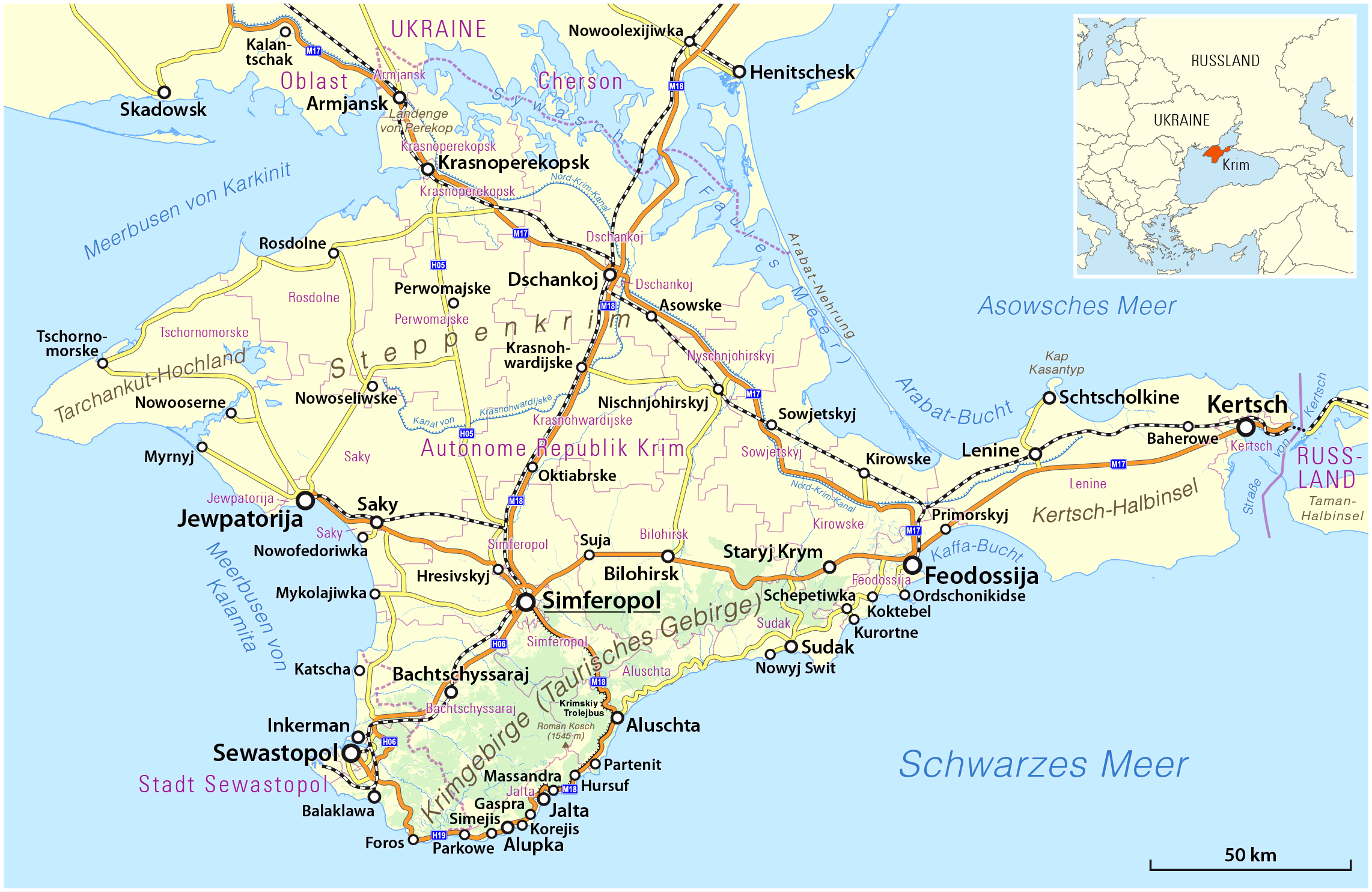
Deutsch: Topographische Karte der Krim, (de:Deutsch-russische Transkription bzw. de:Transkription_(Schreibung)#Kyrillisch)
English: Topographic map of the Crimea peninsula |
|||
| Datum | see file history | |||
| Žrědło |
Swójske źěło, using
|
|||
| Awtor | Maximilian Dörrbecker (Chumwa) | |||
| Dowolenje (dalewužiwanje tuteje dataje) |
Toś ta dataja jo pód licencu Creative Commons Attribution-Share Alike 2.0 Generic licencěrowana
Sie dürfen das Bild zu den folgenden Bedingungen nutzen:
|
|||
| Druge wersije toś teje dataje |
|


Stawizny dataje
Tłoc na datum/cas aby tencasna wersija se lodowała.
| datum/cas | Pśeglědowy wobraz | rozměry | Wužywaŕ | Komentar | |
|---|---|---|---|---|---|
| něntejšny | 2. decembra 2016, 01:10 | | 2.283x1.485 (1.014 kB) | Chumwa | |
| 9. apryla 2014, 04:00 |  | 2.283x1.485 (643 kB) | Centovalli | optipng | |
| 8. apryla 2014, 21:11 |  | 2.283x1.485 (1.014 kB) | Chumwa | ||
| 7. apryla 2014, 07:20 |  | 2.283x1.485 (1.014 kB) | Chumwa | ||
| 6. apryla 2014, 04:21 |  | 2.283x1.485 (643 kB) | Cheschtenebaum | optipng | |
| 5. apryla 2014, 21:50 |  | 2.283x1.485 (1.013 kB) | Chumwa | ||
| 31. měrca 2014, 11:28 |  | 2.283x1.485 (653 kB) | Kopiersperre | optipng | |
| 26. měrca 2014, 20:23 |  | 2.283x1.485 (1,01 MB) | Cheschtenebaum | Azowske --> Asowske | |
| 24. měrca 2014, 19:32 |  | 2.283x1.485 (1.012 kB) | Chumwa | ||
| 22. měrca 2014, 17:18 |  | 2.283x1.485 (1.012 kB) | Chumwa |
Datajowe wužywanje
Slědujucy bok wótkazujo na toś tu dataju:
Globalne wužywanje datajow
Slědujuce druge wikije wužywaju toś ten wobraz:
- Wužywanje na als.wikipedia.org
- Wužywanje na ar.wikipedia.org
- Wužywanje na ba.wikipedia.org
- Wužywanje na be.wikipedia.org
- Wužywanje na bg.wikipedia.org
- Wužywanje na ca.wikipedia.org
- Wužywanje na crh.wikipedia.org
- Wužywanje na de.wikipedia.org
- Krim
- Simferopol
- Sewastopol
- Feodossija
- Benutzer:Chumwa
- Krymskyj trolejbus
- Liste ukrainischer Inseln
- Annexion der Krim 2014
- Referendum über den Status der Krim
- Wikipedia:Kartenwerkstatt/Karte des Tages/Galerie
- Benutzer:Chumwa/SomeOfMyFiles
- Wikipedia:Hauptseite/Archiv/24. März 2021
- Wikipedia:Hauptseite/Archiv/25. März 2021
- Wikipedia:Hauptseite/Archiv/26. März 2021
- Ekim Kara
- Kefessija
- Dschewat Kara
- Wužywanje na el.wikipedia.org
- Wužywanje na en.wikipedia.org
- Wužywanje na en.wiktionary.org
- Wužywanje na es.wikipedia.org
- Wužywanje na et.wikipedia.org
- Wužywanje na fa.wikipedia.org
- Wužywanje na fi.wikipedia.org
- Wužywanje na fi.wikivoyage.org
- Wužywanje na fo.wikipedia.org
- Wužywanje na frr.wikipedia.org
- Wužywanje na fy.wikipedia.org
- Wužywanje na ga.wikipedia.org
- Wužywanje na gl.wikipedia.org
Dalšne globalne wužywanje toś teje dataje pokazaś.