
Dataja:Feldberger Seen zur Havel & zur Ucker.png

Wjelikosć toś togo pśeglěda: 800 × 485 pikselow. Druge rozeznaśa: 320 × 194 pikselow | 640 × 388 pikselow | 1.024 × 620 pikselow | 1.280 × 776 pikselow | 2.560 × 1.551 pikselow | 5.083 × 3.080 pikselow.
Originalna dataja (5.083 × 3.080 pikselow, wjelikosć dataje: 5,66 MB, MIME-Typ: image/png)
- This map in 20% projection – Cette carte en projection de 20% – Diese Karte in 20%-Projektion – 1271 x 770 px
- This map in 25% projection – Cette carte en projection de 25% – Diese Karte in 25%-Projektion – 1674 x 1027 px
- This map in 33% projection – Cette carte en projection de 33% – Diese Karte in 33%-Projektion – 2542 x 1540 px
- == Zespominanje ==
| wopis |
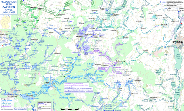
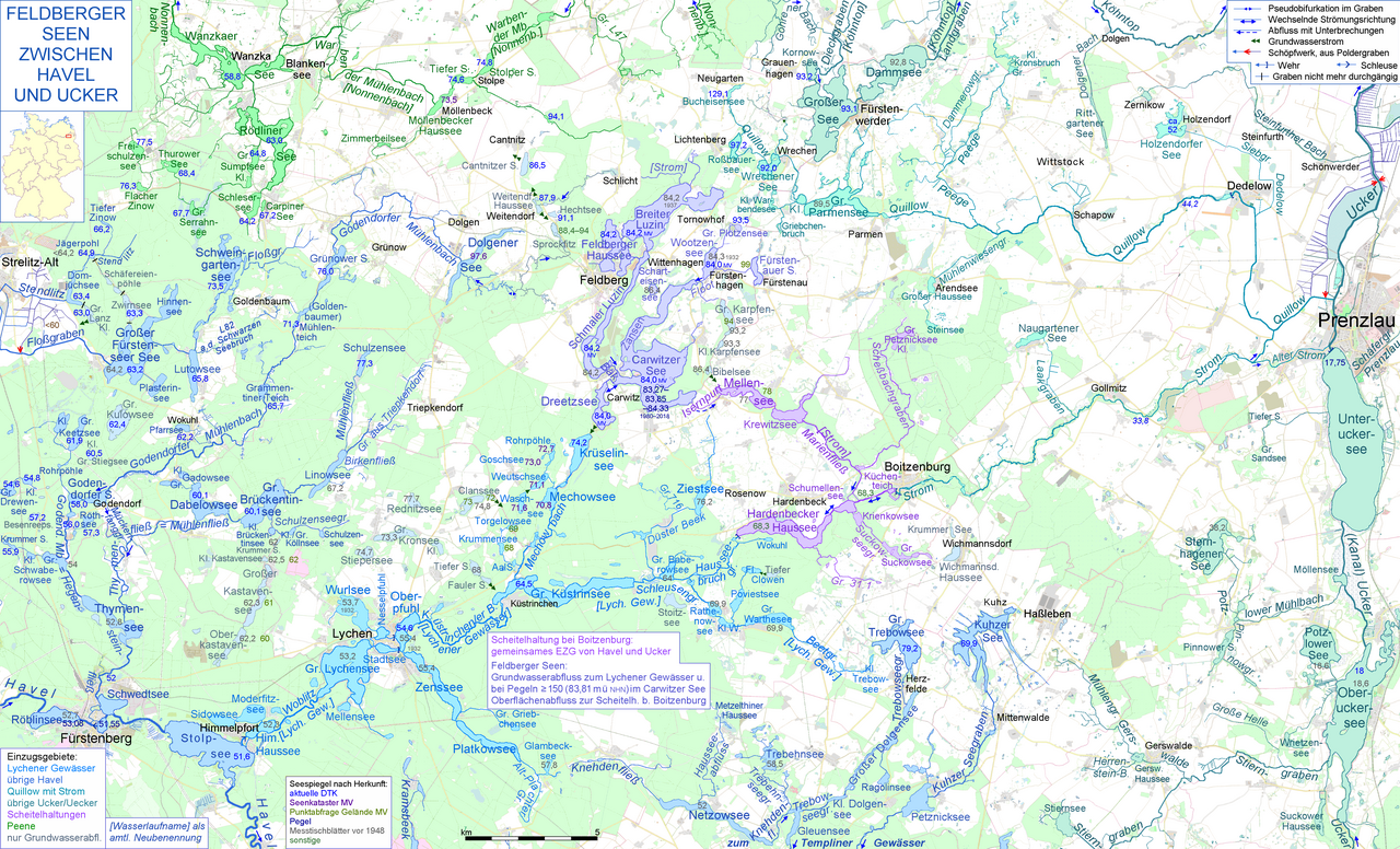
Deutsch: Die Feldberger Seen entwässern durch einen Grundwasserstrom ins Lychener Gewässer und damit zur Havel, außerdem bei ausreichendem Wasserstand im Carwitzer See durch die heute verrohrte Isernpurt zu einer Scheitelheltung bei Boitzenburg, die sowohl zu dem Einzugsgebiet der Ucker (Ablaufweg durch Strom und untere Quillow) als auch zu dem der Havel gehört (Ablaufweg wiederum durch das Lychener Gewässer). Die Karte zeigt beide Ablaufwege und reicht von der Havel bei Fürstenberg und Himmelpfort im Südwesten bis zur Ucker mit Oberuckersee, Unteruckersee und Prenzlau im Osten English: Map of the Lakes around Feldberg (the municipality of Feldberger Seenlandschaft), showing their ambiguating routes of discharge, the two western routes via ground water and via open-air waterways to river Havel at Himmelpfort near Fürstenberg and the eastern course to river Ucker near Prenzlau |
|||||||||||||||
| Datum | ||||||||||||||||
| Žrědło |
& Swójske źěło,
|
|||||||||||||||
| Awtor | Ulamm (diskusija) |
Licencěrowanje
Ja, awtor tutoho dźěła, wozjewjam je z tym pod slědowacymi licencami:

|
Směće tutón dokument pod wuměnjenjemi licency GNU Free Documentation License, wersija 1.2 abo nowša wersija, wozjewjeneje wot załožby Free Software Foundation kopěrować, rozšěrjeć a/abo změnić; njejsu njezměnite wotrězki, njeje žadyn prědni a žadyn zadni wobalkowy tekst. Kopija licency je we wotrězku z titulom GNU Free Documentation License wobsahowana. |
This file is licensed under the Creative Commons Attribution-Share Alike 4.0 International, 3.0 Unported, 2.5 Generic, 2.0 Generic and 1.0 Generic license.
- Smějoš:
- gromaźe wužywaś – źěło kopěrowaś, rozšyriś a dalej daś
- změšaś – aby źěło pśiměrił
- Pód slědujucymi wuměnjenjami:
- pśipokazanje – Musyš źěło pó wašni pśipokazaś, kótaruž awtor abo licencowaŕ jo pódał (ale nic pó wašni, až by se gódało, až wón tebje abo twójo wužywanje źěła schwalijo).
- źěliś – Jolic měnjaš, pśetworjaš toś to źěło abo na njo natwarjaš, móžoš gótowe źěło jano pód teju sameju licencu ako toś ta rozšyriś.
Móžoš licencu swójeje wólby wubraś.
Stawizny dataje
Tłoc na datum/cas aby tencasna wersija se lodowała.
| datum/cas | Pśeglědowy wobraz | rozměry | Wužywaŕ | Komentar | |
|---|---|---|---|---|---|
| něntejšny | 7. julija 2019, 21:02 | | 5.083x3.080 (5,66 MB) | Ulamm | some more details |
| 25. junija 2019, 22:51 |  | 5.083x3.080 (5,66 MB) | Ulamm | Laakgraben is the outlet of Naugartener See. | |
| 6. junija 2019, 08:40 |  | 5.083x3.080 (5,66 MB) | Ulamm | outlets of Kleiner Warbendesee & Großer Sandsee | |
| 27. maja 2019, 09:57 |  | 5.083x3.080 (5,66 MB) | Ulamm | one more label | |
| 27. maja 2019, 08:58 |  | 5.083x3.080 (5,66 MB) | Ulamm | corrections alike File:Floßgraben & Kammerkanal.png | |
| 22. maja 2019, 23:58 |  | 5.083x3.080 (5,66 MB) | Ulamm | wells of Floßgraben | |
| 22. maja 2019, 12:32 |  | 5.083x3.080 (5,66 MB) | Ulamm | level elevation of Carwitzer See from gauge values | |
| 19. maja 2019, 19:57 |  | 5.083x3.080 (5,67 MB) | Ulamm | some more water level elevations | |
| 19. maja 2019, 00:47 |  | 5.083x3.080 (5,66 MB) | Ulamm | correction of an elevation and a name, and some additions | |
| 17. maja 2019, 06:34 |  | 5.083x3.080 (5,67 MB) | Ulamm | small details in Boitzenburg |
Datajowe wužywanje
Žedne boki njewótkazuju na toś tu dataju.
Globalne wužywanje datajow
Slědujuce druge wikije wužywaju toś ten wobraz:
- Wužywanje na de.wikipedia.org
- Wužywanje na hu.wikipedia.org