Dataja:Feldberger Seen + Abflusswege.png

Seiteninhalte werden in anderen Sprachen nicht unterstützt.
Z Wikipedije

Originalna dataja(2.609 × 2.574 pikselow, wjelikosć dataje: 2,25 MB, MIME-Typ: image/png)

Toś ta dataja jo z Wikimedia Commons a dajo se pśez druge projekty wužywaś. Wopisanje na jeje boku datajowego wopisanja pokazujo se dołojce.

Zespominanje

wopis
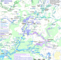
Deutsch: Karte der Feldberger Seen und ihrer Abflusswege. Namen, die von den in den DTK zu findenden abweichen, sind von Gewässerfachleuten der Wasser- und Bodenverbände erfragt. Einige findet man auch in Wasserkörpersteckbriefen. Die meisten erforderlichen Daten und Gewässerdefinitionen entstammen dem Umweltportal des LUNG
English: Map of the Lakes in the municipality of Feldberger Seenlandschaft; names differring from those written in topographic maps haved been collected from water specialists of the maintaining institutions.
Datum
Žrědło
Beschreibung
This map was created from OpenStreetMap project data, collected by the community. This map may be incomplete, and may contain errors. Don't rely solely on it for navigation.
Datum (see file history)
Žrědło openstreetmap.org
Tworićel
OpenStreetMap contributors
Dowolenje
(dalewužiwanje tuteje dataje)

OpenStreetMap data is available under the Open Database License (details). Map tiles are licensed under the Creative Commons Attribution-ShareAlike 2.0 license (CC-BY-SA 2.0).

This work contains information from OpenStreetMap, which is made available under the Open Database License (ODbL).

The ODbL does not require any particular license for maps produced from ODbL data. Prior to 1 August 2020, map tiles produced by the OpenStreetMap Foundation were licensed under the CC-BY-SA-2.0 license. Maps produced by other people may be subject to other licences.

w:dsb:Creative Commons
pśipokazanje źěliś
Toś ta dataja jo pód licencu Creative Commons Attribution-Share Alike 2.0 Generic licencěrowana
Smějoš:
  • gromaźe wužywaś – źěło kopěrowaś, rozšyriś a dalej daś
  • změšaś – aby źěło pśiměrił
Pód slědujucymi wuměnjenjami:
  • pśipokazanje – Musyš źěło pó wašni pśipokazaś, kótaruž awtor abo licencowaŕ jo pódał (ale nic pó wašni, až by se gódało, až wón tebje abo twójo wužywanje źěła schwalijo).
  • źěliś – Jolic měnjaš, pśetworjaš toś to źěło abo na njo natwarjaš, móžoš gótowe źěło jano pód teju sameju licencu ako toś ta rozšyriś.
Georeferenzierung Bitte hilf mit, diese Karte zu georeferenzieren If inappropriate please set warp_status = skip to hide.
& Swójske źěło,
Awtor Ulamm (diskusija)

Licencěrowanje

Ja, awtor tutoho dźěła, wozjewjam je z tym pod slědowacymi licencami:
GNU head Směće tutón dokument pod wuměnjenjemi licency GNU Free Documentation License, wersija 1.2 abo nowša wersija, wozjewjeneje wot załožby Free Software Foundation kopěrować, rozšěrjeć a/abo změnić; njejsu njezměnite wotrězki, njeje žadyn prědni a žadyn zadni wobalkowy tekst. Kopija licency je we wotrězku z titulom GNU Free Documentation License wobsahowana.
w:dsb:Creative Commons
pśipokazanje źěliś
This file is licensed under the Creative Commons Attribution-Share Alike 4.0 International, 3.0 Unported, 2.5 Generic, 2.0 Generic and 1.0 Generic license.
Smějoš:
  • gromaźe wužywaś – źěło kopěrowaś, rozšyriś a dalej daś
  • změšaś – aby źěło pśiměrił
Pód slědujucymi wuměnjenjami:
  • pśipokazanje – Musyš źěło pó wašni pśipokazaś, kótaruž awtor abo licencowaŕ jo pódał (ale nic pó wašni, až by se gódało, až wón tebje abo twójo wužywanje źěła schwalijo).
  • źěliś – Jolic měnjaš, pśetworjaš toś to źěło abo na njo natwarjaš, móžoš gótowe źěło jano pód teju sameju licencu ako toś ta rozšyriś.
Móžoš licencu swójeje wólby wubraś.

Krótkowopisy

Dodaj jednolinkowy wopis tuteje dataje.

W tutej dataji zwobraznjene objekty

motiw górnoserbšćina

tworićel górnoserbšćina

Někajka hódnota bjez zapiska pola Wikidata

awtor (tekst) górnoserbšćina: Ulamm
objekt ma rólu górnoserbšćina: fotograf górnoserbšćina

status awtorskich prawow górnoserbšćina

žórło dataje górnoserbšćina

1. apryla 2019

Stawizny dataje

Tłoc na datum/cas aby tencasna wersija se lodowała.

datum/casPśeglědowy wobrazrozměryWužywaŕKomentar
něntejšny7. julija 2019, 21:17Pśeglědowy wobraz za wersiju wót 7. julija 2019, 21:172.609x2.574 (2,25 MB)Ulammtypography
25. junija 2019, 22:54Pśeglědowy wobraz za wersiju wót 25. junija 2019, 22:542.609x2.574 (2,25 MB)Ulammmore lakes with outlet streams
22. maja 2019, 12:36Pśeglědowy wobraz za wersiju wót 22. maja 2019, 12:362.609x2.574 (2,25 MB)Ulammlevel elevation of Carwitzer See from gauge values
19. maja 2019, 19:52Pśeglědowy wobraz za wersiju wót 19. maja 2019, 19:522.609x2.574 (2,29 MB)Ulammsome more water level elevations and some flow gauges
17. maja 2019, 06:36Pśeglědowy wobraz za wersiju wót 17. maja 2019, 06:362.609x2.574 (2,3 MB)Ulammsmall details in Boitzenburg
16. maja 2019, 02:21Pśeglědowy wobraz za wersiju wót 16. maja 2019, 02:212.609x2.574 (2,3 MB)Ulammsome more water levels
15. maja 2019, 20:11Pśeglědowy wobraz za wersiju wót 15. maja 2019, 20:112.609x2.574 (2,3 MB)Ulammalmost completely new map, cutout of File:Feldberger Seen zur Havel & zur Ucker.png
19. apryla 2019, 23:38Pśeglědowy wobraz za wersiju wót 19. apryla 2019, 23:381.941x2.196 (1,36 MB)UlammBaberowsee
19. apryla 2019, 21:46Pśeglědowy wobraz za wersiju wót 19. apryla 2019, 21:461.941x2.196 (1,36 MB)Ulamm* Höhe des Bibelsees, dadurch Grundwasserabfluss aus Karpfenseen eindeutig zu den Feldberger Seen.<br /> * Loco-map
18. apryla 2019, 02:28Pśeglědowy wobraz za wersiju wót 18. apryla 2019, 02:281.941x2.196 (1,37 MB)Ulamm{{Information |Description= {{de|Karte der Flusssysteme von Peene, Zarow, Recknitz und Ryck; ohne Reliefhintergrund. Namen, die von den in den DTK zu findenden abweichen, sind von Gewässerfachleuten der Wasser- und Bodenverbände erfragt. Einige findet man auch in Wasserkörpersteckbriefen. Die meisten erforderlichen Daten und Gewässerdefinitionen entstammen dem Umweltportal des LUNG}}{{en|Map of the basins of the rivers Peene, Zarow, Recknitz and Ryck; without relief background. name differrin...

Slědujucy bok wótkazujo na toś tu dataju:

Globalne wužywanje datajow

Metadaty