
Dataja:Pacific Ring of Fire.png
Wjelikosć toś togo pśeglěda: 800 × 593 pikselow. Drugej rozeznaśi: 320 × 237 pikselow | 640 × 475 pikselow | 1.024 × 760 pikselow | 1.046 × 776 pikselow.
Originalna dataja (1.046 × 776 pikselow, wjelikosć dataje: 66 kB, MIME-Typ: image/png)

|
File:Pacific Ring of Fire.svg ist eine vektorisierte Version dieses Bildes. Diese sollte an Stelle des Rasterbildes verwendet werden.
File:Pacific Ring of Fire.png → File:Pacific Ring of Fire.svg
Für weitere Informationen siehe Help:SVG. |
 |
Zespominanje
| wopis |
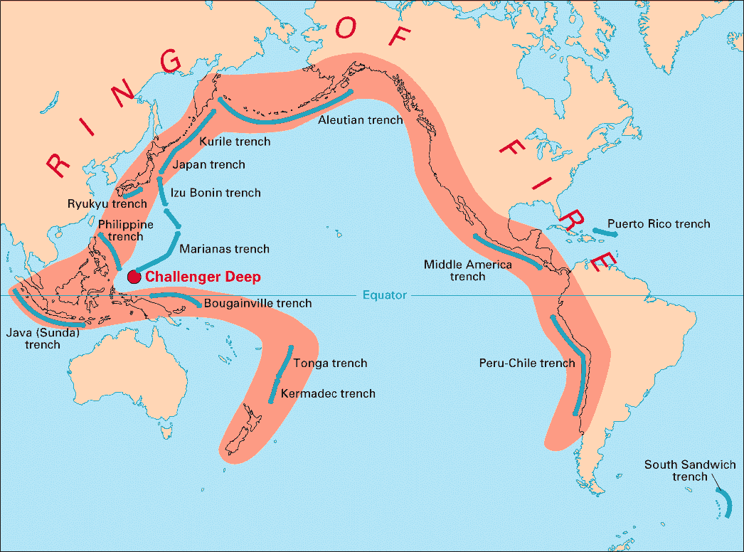
English: Volcanic arcs and oceanic trenches partly encircling the Pacific Basin form the so-called Pacific Ring of fire, a zone of frequent earthquakes and volcanic eruptions. The trenches are shown in blue-green. The volcanic island arcs, although not labelled, are parallel to, and always landward of, the trenches. For example, the island arc associated with the Aleutian Trench is represented by the long chain of volcanoes that make up the Aleutian Islands. |
| Datum | |
| Žrědło | http://pubs.usgs.gov/publications/text/fire.html |
| Awtor | USGS |
Licencěrowanje
Dieses Bild ist gemeinfrei (public domain), weil es Materialien beeinhaltet, die ursprünglich vom United States Geological Survey, einer Behörde des Innenministeriums der Vereinigten Staaten, stammen. Weitere Informationen finden Sie in den Urheberrechtsbestimmungen des USGS
|
Stawizny dataje
Tłoc na datum/cas aby tencasna wersija se lodowała.
| datum/cas | Pśeglědowy wobraz | rozměry | Wužywaŕ | Komentar | |
|---|---|---|---|---|---|
| něntejšny | 28. decembra 2004, 05:28 | | 1.046x776 (66 kB) | Ævar Arnfjörð Bjarmason | Deeper colours |
| 28. decembra 2004, 05:26 |  | 1.046x776 (156 kB) | Ævar Arnfjörð Bjarmason |
Datajowe wužywanje
Slědujucy bok wótkazujo na toś tu dataju:
Globalne wužywanje datajow
Slědujuce druge wikije wužywaju toś ten wobraz:
- Wužywanje na als.wikipedia.org
- Wužywanje na ar.wikipedia.org
- Wužywanje na ary.wikipedia.org
- Wužywanje na bs.wikipedia.org
- Wužywanje na ca.wikipedia.org
- Wužywanje na da.wikipedia.org
- Wužywanje na en.wikipedia.org
- Wužywanje na en.wikibooks.org
- Wužywanje na eo.wikipedia.org
- Wužywanje na eu.wikipedia.org
- Wužywanje na fr.wikipedia.org
- Wužywanje na gl.wikipedia.org
- Wužywanje na hr.wikipedia.org
- Wužywanje na hsb.wikipedia.org
- Wužywanje na id.wikipedia.org
- Wužywanje na it.wikipedia.org
- Wužywanje na ko.wikipedia.org
- Wužywanje na ko.wikinews.org
- Wužywanje na lt.wikipedia.org
- Wužywanje na lv.wikipedia.org
- Wužywanje na mg.wikipedia.org
- Wužywanje na ms.wikipedia.org
- Wužywanje na nia.wikipedia.org
- Wužywanje na nl.wikipedia.org
- Wužywanje na nn.wikipedia.org
- Wužywanje na no.wikipedia.org
- Wužywanje na pap.wikipedia.org
- Wužywanje na pnb.wikipedia.org
- Wužywanje na ro.wikipedia.org
- Wužywanje na simple.wikipedia.org
- Wužywanje na sk.wikipedia.org
- Wužywanje na sl.wikipedia.org
- Wužywanje na sr.wikipedia.org
- Wužywanje na su.wikipedia.org
- Wužywanje na sv.wikipedia.org
Dalšne globalne wužywanje toś teje dataje pokazaś.