
Dataja:LocationCzechoslovakia.png
Wuše wótgranicowanje njeeksistěrujo.
LocationCzechoslovakia.png (250 × 229 pikselow, wjelikosć dataje: 10 kB, MIME-Typ: image/png)

|
File:Czechoslovakia location map.svg ist eine vektorisierte Version dieses Bildes. Diese sollte an Stelle des Rasterbildes verwendet werden, sofern sie nicht schlechter ist.
File:LocationCzechoslovakia.png → File:Czechoslovakia location map.svg
Für weitere Informationen siehe Help:SVG. |
 |
| wopis |
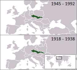
English: Location of Czechoslovakia 1918–1938 and 1945–1992 (other european borders are correct for: 1919–1922 / 1956–1990) |
| Žrědło | From en.wikipedia |
| Awtor | First uploaded to en: by en:User:Morwen, extended to the "first republic" by en:User:Hexagon1. |
| Ich, der Urheberrechtsinhaber dieses Werkes, veröffentliche es als gemeinfrei. Dies gilt weltweit. W někotrych krajach je to snano prawnisce njemóžno; jeli tomu tak je: Ich gewähre jedem das bedingungslose Recht, dieses Werk für jedweden Zweck zu nutzen, es sei denn, Bedingungen sind gesetzlich erforderlich. |
Stawizny dataje
Tłoc na datum/cas aby tencasna wersija se lodowała.
| datum/cas | Pśeglědowy wobraz | rozměry | Wužywaŕ | Komentar | |
|---|---|---|---|---|---|
| něntejšny | 22. julija 2008, 20:03 | | 250x229 (10 kB) | Quadpus~commonswiki | Reverted to version as of 02:57, 30 May 2007 poor quality image, unknown reason for changing |
| 16. julija 2008, 04:29 |  | 250x342 (12 kB) | Rodolfo2008 | {{Information |Description=Location of Czechoslovakia 1918–1938 and 1945–1992and 1990-1993 (other european borders are correct for: 1919–1938 / 1956–1990) |Source=From en.wikipedia |Date= |Author=Rodolfo Perez Peña |Permission= |other_versions= } | |
| 30. maja 2007, 04:57 |  | 250x229 (10 kB) | Happenstance | larger dates | |
| 30. maja 2007, 04:41 |  | 250x229 (9 kB) | Happenstance | fx | |
| 30. maja 2007, 04:40 |  | 250x229 (10 kB) | Happenstance | borders corrected (correct as of 1921) | |
| 23. januara 2007, 03:13 |  | 250x229 (9 kB) | Happenstance | rv, even though the borders of the surrounding nations changed, that entire period saw borders transition as independences were recognized left, right and centre. I think it's wise to omit these changes because we simply can't have enough boxes to progres | |
| 20. januara 2007, 10:24 |  | 249x344 (14 kB) | Hoshie | added a box for post-communist Czechoslovakia. under same license as original. | |
| 26. nowembra 2006, 03:22 |  | 250x229 (9 kB) | Happenstance | added 1918 to 1938 box | |
| 20. měrca 2005, 12:27 |  | 250x115 (3 kB) | Thuresson | {{GFDL}} |
Datajowe wužywanje
Slědujucy bok wótkazujo na toś tu dataju:
Globalne wužywanje datajow
Slědujuce druge wikije wužywaju toś ten wobraz:
- Wužywanje na ang.wikipedia.org
- Wužywanje na ar.wikipedia.org
- Wužywanje na arz.wikipedia.org
- Wužywanje na azb.wikipedia.org
- Wužywanje na be-tarask.wikipedia.org
- Wužywanje na bn.wikipedia.org
- Wužywanje na bs.wikipedia.org
- Wužywanje na cy.wikipedia.org
- Wužywanje na de.wikipedia.org
- Wužywanje na et.wikipedia.org
- Wužywanje na frp.wikipedia.org
- Wužywanje na fr.wiktionary.org
- Wužywanje na fy.wikipedia.org
- Wužywanje na hsb.wikipedia.org
- Wužywanje na hy.wikipedia.org
- Wužywanje na incubator.wikimedia.org
- Wužywanje na io.wikipedia.org
- Wužywanje na kn.wikipedia.org
- Wužywanje na ku.wikipedia.org
- Wužywanje na la.wiktionary.org
- Wužywanje na mr.wikipedia.org
- Wužywanje na mzn.wikipedia.org
- Wužywanje na nl.wikipedia.org
- Wužywanje na nn.wikipedia.org
- Wužywanje na no.wikipedia.org
- Wužywanje na oc.wikipedia.org
- Wužywanje na pl.wiktionary.org
- Wužywanje na pt.wikiquote.org
- Wužywanje na pt.wiktionary.org
- Wužywanje na qu.wikipedia.org
- Wužywanje na scn.wikipedia.org
- Wužywanje na si.wikipedia.org
- Wužywanje na sl.wikipedia.org
- Wužywanje na sr.wikipedia.org
Dalšne globalne wužywanje toś teje dataje pokazaś.