
Dataja:Limes2.png
Wjelikosć toś togo pśeglěda: 600 × 600 pikselow. Druge rozeznaśa: 240 × 240 pikselow | 480 × 480 pikselow | 768 × 768 pikselow | 1.024 × 1.024 pikselow | 2.048 × 2.048 pikselow | 5.906 × 5.906 pikselow.
Originalna dataja (5.906 × 5.906 pikselow, wjelikosć dataje: 15,34 MB, MIME-Typ: image/png)
Zespominanje
| wopis |
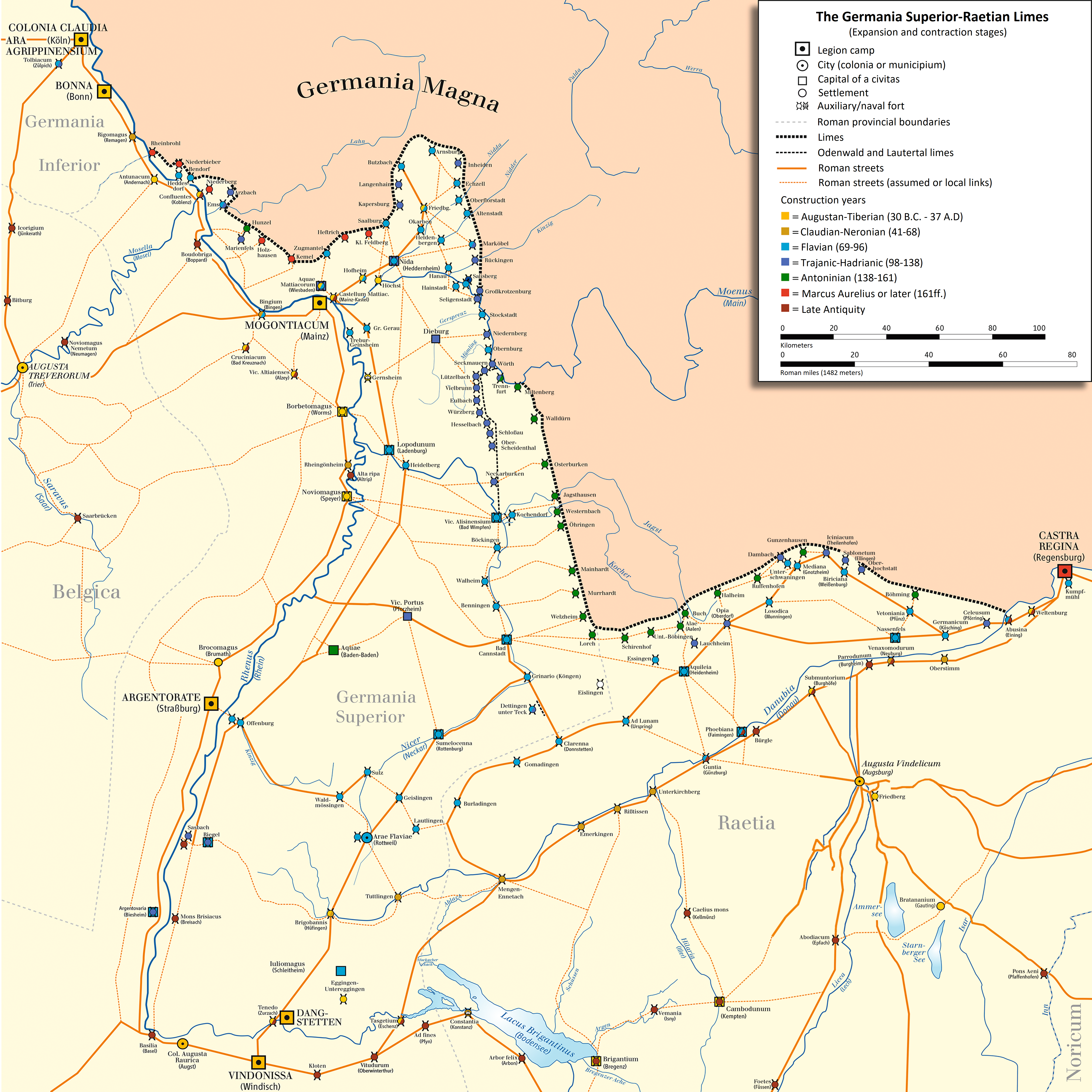
English: Map of Limes Germanicus (system of fortifications representing the boundary of Roman control in the Rhine-Danube angle)
Deutsch: Karte des Obergermanisch-Raetischen Limes |
| Datum | |
| Žrědło | own drawing/Source of Information: Martin Kemkes: „Römer an Donau und Iller. Neue Forschungen und Funde.“ Thorbecke, Sigmaringen 1996, ISBN 3-7995-0410-9, S. 152f.; Dietwulf Baatz: Der Römische Limes. Archäologische Ausflüge zwischen Rhein und Donau. 4. Auflage. Gebr. Mann, Berlin 2000, ISBN 3-7861-2347-0; Thomas Fischer und Günther Ulbert: Der Limes in Bayern. Von Dinkelsbühl bis Eining. Theiss, Stuttgart 1983, ISBN 3-8062-0351-2; Heinz Cüppers: Die Römer in Rheinland-Pfalz. Lizenzausgabe. Nikol, Hamburg 2002. ISBN 3-933203-60-0; Cliff Alexander Jost: Der römische Limes in Rheinland-Pfalz. (Archäologie an Mittelrhein und Mosel, Band 14), Landesamt für Denkmalpflege Rheinland-Pfalz, Koblenz 2003, ISBN 3-929645-07-6; Dietwulf Baatz und Fritz-Rudolf Herrmann: Die Römer in Hessen. Lizenzausgabe. Nikol, Hamburg 2002, ISBN 3-933203-58-9; Dieter Planck (Hrsg.): Die Römer in Baden-Württemberg. Theiss, Stuttgart 2005, ISBN 3-8062-1555-3; Philipp Filtzinger, Dieter Planck und Bernhard Cämmerer (Hrsg.): Die Römer in Baden-Württemberg. 3. Auflage. Theiss, Stuttgart 1986, ISBN 3-8062-0287-7; Wolfgang Czysz u.a.: Die Römer in Bayern. Lizenzausgabe. Nikol, Hamburg 2005, ISBN 3-937872-11-6; Dieter Planck u.a.: Imperium Romanum. Roms Provinzen an Neckar, Rhein und Donau. Theiss, Stuttgart 2005. ISBN 978-3-8062-2140-4 |
| Awtor | ziegelbrenner |
| Druge wersije toś teje dataje | Italian version |

|
Dieses Bild des Typs Historical map sollte als Vektorgrafik im SVG-Format neu erstellt werden. Vektorformate haben zahlreiche Vorteile; weitere Information unter Commons:Media for cleanup. Wenn dir eine SVG-Version dieses Bildes vorliegt, so lade diese bitte hoch. Nach dem Hochladen der Datei ist diese Vorlage auf der aktuellen Bildbeschreibungsseite durch die Vorlage {{Vector version available}}, oder kürzer {{Vva}}, zu ersetzen. Es ist empfohlen die neue SVG-Datei „Limes2.svg“ zu nennen – dann benötigt die Vorlage vector version available (bzw. vva) keinen Parameter.
|

|
Diese Karte wurde in der Kartenwerkstatt erstellt oder verbessert. Auch du kannst dort Karten vorschlagen, die zu erstellen, verändern oder übersetzen sind.
|
Licencěrowanje
Ja, awtor tutoho dźěła, wozjewjam je z tym pod slědowacymi licencami:

|
Směće tutón dokument pod wuměnjenjemi licency GNU Free Documentation License, wersija 1.2 abo nowša wersija, wozjewjeneje wot załožby Free Software Foundation kopěrować, rozšěrjeć a/abo změnić; njejsu njezměnite wotrězki, njeje žadyn prědni a žadyn zadni wobalkowy tekst. Kopija licency je we wotrězku z titulom GNU Free Documentation License wobsahowana. |
Toś ta dataja jo pód licencu Creative Commons Attribution-Share Alike 3.0 Unported licencěrowana
- Smějoš:
- gromaźe wužywaś – źěło kopěrowaś, rozšyriś a dalej daś
- změšaś – aby źěło pśiměrił
- Pód slědujucymi wuměnjenjami:
- pśipokazanje – Musyš źěło pó wašni pśipokazaś, kótaruž awtor abo licencowaŕ jo pódał (ale nic pó wašni, až by se gódało, až wón tebje abo twójo wužywanje źěła schwalijo).
- źěliś – Jolic měnjaš, pśetworjaš toś to źěło abo na njo natwarjaš, móžoš gótowe źěło jano pód teju sameju licencu ako toś ta rozšyriś.
Móžoš licencu swójeje wólby wubraś.
| Bildnotizen | Diese Datei ist annotiert: Betrachte diese auf Commons. |

Stawizny dataje
Tłoc na datum/cas aby tencasna wersija se lodowała.
| datum/cas | Pśeglědowy wobraz | rozměry | Wužywaŕ | Komentar | |
|---|---|---|---|---|---|
| něntejšny | 16. oktobra 2023, 21:10 | | 5.906x5.906 (15,34 MB) | MrThe1And0nly | Translated the legend into English |
| 15. decembra 2017, 17:22 |  | 5.906x5.906 (11,1 MB) | Mediatus | Gauting eingefügt | |
| 14. decembra 2017, 21:29 |  | 5.906x5.906 (11,09 MB) | Mediatus | Pförring verbessert | |
| 14. decembra 2017, 19:03 |  | 5.906x5.906 (11,09 MB) | Mediatus | Nachträge und Verbesserungen | |
| 19. junija 2017, 16:52 |  | 5.906x5.906 (13,22 MB) | Mediatus | Augsburger Raum nach LDA | |
| 19. junija 2017, 12:22 |  | 2.946x3.046 (2,74 MB) | Mediatus | gef. | |
| 16. januara 2017, 18:52 |  | 2.953x2.953 (2,73 MB) | Ziegelbrenner | corrected | |
| 16. měrca 2013, 17:59 |  | 2.946x3.046 (2,74 MB) | Mediatus | ausgebaut | |
| 13. oktobra 2011, 15:47 |  | 2.362x2.440 (1,87 MB) | Ziegelbrenner | 2011-10-13 | |
| 11. januara 2010, 13:47 |  | 2.362x2.362 (1,76 MB) | Ziegelbrenner | 2010-01-11 |
Datajowe wužywanje
Slědujucy bok wótkazujo na toś tu dataju:
Globalne wužywanje datajow
Slědujuce druge wikije wužywaju toś ten wobraz:
- Wužywanje na als.wikipedia.org
- Wužywanje na bs.wikipedia.org
- Wužywanje na cs.wikipedia.org
- Wužywanje na da.wikipedia.org
- Wužywanje na de.wikipedia.org
- Konstanz
- Obergermanisch-Raetischer Limes
- Augusta Vindelicum
- Diskussion:Obergermanisch-Raetischer Limes
- Liste der Kastelle am Obergermanisch-Raetischen Limes
- Antunnacum
- Limes (Grenzwall)
- Urgeschichte Baden-Württembergs
- Metropolregion Rhein-Neckar
- Castra Regina
- Donau-Iller-Rhein-Limes
- Kastell Köngen
- Neckar-Odenwald-Limes
- Via Danubia
- Wetterau
- Borbetomagus
- Kastell Eining
- Iuliomagus (Schleitheim)
- Kastell Wimpfen im Tal
- Kastell Heilbronn-Böckingen
- Kastell Ennetach
- Kastell Rißtissen
- Wikipedia:Redaktion Altertum/Römischer Limes
- Vorlage Diskussion:Infobox Limeskastell
- Kastell Benningen
- Kastell Stuttgart-Bad Cannstatt
- Kastelle von Walheim
- Kastell Sulz
- Kastell Waldmössingen
- Kastell Emerkingen
- Kastell Hüfingen
- Kastell Unterkirchberg
- Kastell Tuttlingen
- Kastell Boppard
- Wikipedia:Redaktion Altertum/Römischer Limes/Pictothek
- Kleinkastell „Auf der Schanz“
- Kastell Alzey
- Wikipedia:Redaktion Altertum/Römischer Limes/Sonstige Baustellen
Dalšne globalne wužywanje toś teje dataje pokazaś.