
Dataja:Land given up to Silesian dukes (Dr. T. Szulc).jpg

Originalna dataja (1.266 × 779 pikselow, wjelikosć dataje: 218 kB, MIME-Typ: image/jpeg)
.jpg)
| wopis |
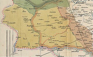
English: Part of a historical map of Greater Poland (Middle Ages) made by Dr. T. Szulc and included in the 4th volume of Codex diplomaticus Maioris Poloniae, covering a Lubusz Land and land given up to Silesian dukes by the Greatpoland dukes Polski: Fragment historycznej mapy Wielkopolski w epoce piastowskiej wykonanej przez Dr. T. Szulca i zamieszczonej w czwartym tomie Kodeksu dyplomatycznego Wielkopolski, obrazujący Ziemię Lubuską (granice diecezji lubuskiej) oraz obszar odstąpiony książętom śląskim przez książąt wielkopolskich |
| Datum | (UTC) |
| Žrědło | |
| Awtor |
|
| Dieses Bild wurde digital nachbearbeitet. Folgende Änderungen wurden vorgenommen: Extracting part of the map to cover Lubusz Land. Das Originalbild kann hier eingesehen werden: WielkoPolska epoki Piastowskiej.jpg:
|
|
Dieses Werk ist gemeinfrei, weil seine urheberrechtliche Schutzfrist abgelaufen ist.
| |
| Es wurde festgestellt, dass diese Datei frei von bekannten Beschränkungen durch das Urheberrecht ist, alle verbundenen und verwandten Rechte eingeschlossen. | |
Originalny protokol nagraśow
This image is a derivative work of the following images:
- File:WielkoPolska_epoki_Piastowskiej.jpg licensed with PD-old
- 2009-06-22T15:28:59Z Paelius 4075x3613 (10969409 Bytes) {{Information |Description={{en|1=Historical map of Greater Poland (Middle Ages) made by Dr. T. Szulc and included in the 4th volume of Codex diplomaticus Maioris Poloniae}} {{pl|1=Historyczna mapa Wielkopolski w epoce piasto
Hochgeladen mit derivativeFX
Stawizny dataje
Tłoc na datum/cas aby tencasna wersija se lodowała.
| datum/cas | Pśeglědowy wobraz | rozměry | Wužywaŕ | Komentar | |
|---|---|---|---|---|---|
| něntejšny | 14. januara 2022, 14:32 | | 1.266x779 (218 kB) | Davey2010 | rv vandal - please seek consensus for your changes |
| 13. januara 2022, 21:13 |  | 1.023x1.056 (362 kB) | LechitaPL | Reverted to version as of 20:25, 19 September 2021 (UTC) (vandalized) | |
| 13. januara 2022, 03:23 |  | 1.266x779 (218 kB) | Davey2010 | Reverted to version as of 12:21, 19 August 2009 (UTC) | |
| 19. septembra 2021, 22:25 |  | 1.023x1.056 (362 kB) | LechitaPL | Zmiany | |
| 19. awgusta 2009, 14:21 |  | 1.266x779 (218 kB) | Opole.pl | {{Information |Description={{en|1=Part of a historical map of Greater Poland (Middle Ages) made by Dr. T. Szulc and included in the 4th volume of Codex diplomaticus Maioris Poloniae, covering Lubusz Land}} {{pl|1=Fragment historycznej mapy Wielkopolski w |
Datajowe wužywanje
Žedne boki njewótkazuju na toś tu dataju.
Globalne wužywanje datajow
Slědujuce druge wikije wužywaju toś ten wobraz:
- Wužywanje na ar.wikipedia.org
- Wužywanje na fr.wikipedia.org
- Wužywanje na ru.wikipedia.org
.jpg)