
Dataja:LakeKivu satellite.jpg
Wuše wótgranicowanje njeeksistěrujo.
LakeKivu_satellite.jpg (296 × 464 pikselow, wjelikosć dataje: 21 kB, MIME-Typ: image/jpeg)
Zespominanje
| wopis |
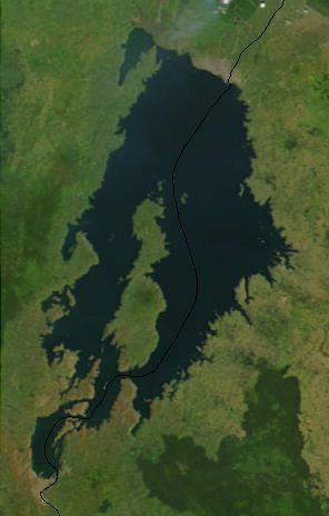
English: Lake Kivu, Africa, as seen from space. The black line marks the border between Rwanda and the Democratic Republic of the Congo. Cropped from a larger image (EAfrica.A2003033.0820.250m.jpg). |
| Datum | |
| Žrědło | "Fires in East Africa" - Visible Earth Image ID 4957 (details, image at 250m resolution) |
| Awtor | NASA |
Licencěrowanje
| Diese Datei ist gemeinfrei (public domain), da sie von der NASA erstellt worden ist. Die NASA-Urheberrechtsrichtlinie besagt, dass „NASA-Material nicht durch Urheberrecht geschützt ist, wenn es nicht anders angegeben ist“. (NASA-Urheberrechtsrichtlinie-Seite oder JPL Image Use Policy). | ||
 |
Warnung:
|
Originalny protokol nagraśow
from en.wikipedia.org
- Uploaded on 23 February 2006 by en:User:Paphrag.
Stawizny dataje
Tłoc na datum/cas aby tencasna wersija se lodowała.
| datum/cas | Pśeglědowy wobraz | rozměry | Wužywaŕ | Komentar | |
|---|---|---|---|---|---|
| něntejšny | 19. septembra 2010, 16:19 | | 296x464 (21 kB) | LobStoR | lossless crop from source NASA image at 250m resolution |
| 25. maja 2006, 00:43 |  | 295x476 (108 kB) | Dubhe | from en.wiki |
Datajowe wužywanje
Slědujucy bok wótkazujo na toś tu dataju:
Globalne wužywanje datajow
Slědujuce druge wikije wužywaju toś ten wobraz:
- Wužywanje na af.wikipedia.org
- Wužywanje na ar.wikipedia.org
- Wužywanje na arz.wikipedia.org
- Wužywanje na ast.wikipedia.org
- Wužywanje na bn.wikipedia.org
- Wužywanje na br.wikipedia.org
- Wužywanje na ca.wikipedia.org
- Wužywanje na ceb.wikipedia.org
- Wužywanje na cs.wikipedia.org
- Wužywanje na da.wikipedia.org
- Wužywanje na de.wikipedia.org
- Wužywanje na de.wikivoyage.org
- Wužywanje na el.wikipedia.org
- Wužywanje na en.wikipedia.org
- Wužywanje na eo.wikipedia.org
- Wužywanje na es.wikipedia.org
- Wužywanje na et.wikipedia.org
- Wužywanje na eu.wikipedia.org
- Wužywanje na fa.wikipedia.org
- Wužywanje na fi.wikipedia.org
- Wužywanje na fr.wikipedia.org
- Wužywanje na fr.wikivoyage.org
- Wužywanje na gl.wikipedia.org
- Wužywanje na he.wikipedia.org
- Wužywanje na hsb.wikipedia.org
- Wužywanje na hy.wikipedia.org
- Wužywanje na ig.wikipedia.org
- Wužywanje na it.wikipedia.org
- Wužywanje na ja.wikipedia.org
- Wužywanje na ka.wikipedia.org
- Wužywanje na ko.wikipedia.org
Dalšne globalne wužywanje toś teje dataje pokazaś.