
Dataja:Kurdish-inhabited area by CIA (1992).jpg
Originalna dataja (982 × 802 pikselow, wjelikosć dataje: 630 kB, MIME-Typ: image/jpeg)
Zespominanje
| wopis |
Ελληνικά: Περιοχές κατοικούμενες από Κούρδους κατά τη CIA (1992) |
| Datum | August 1992 or earlier |
| Žrědło |
Perry-Castañeda Library Map Collection at The University of Texas at Austin [1] linked from Perry-Castañeda Library Map Collection at The University of Texas at Austin |
| Awtor |
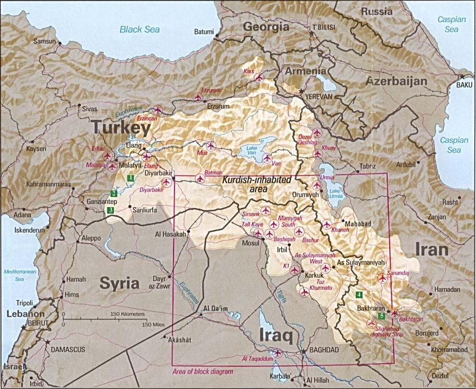
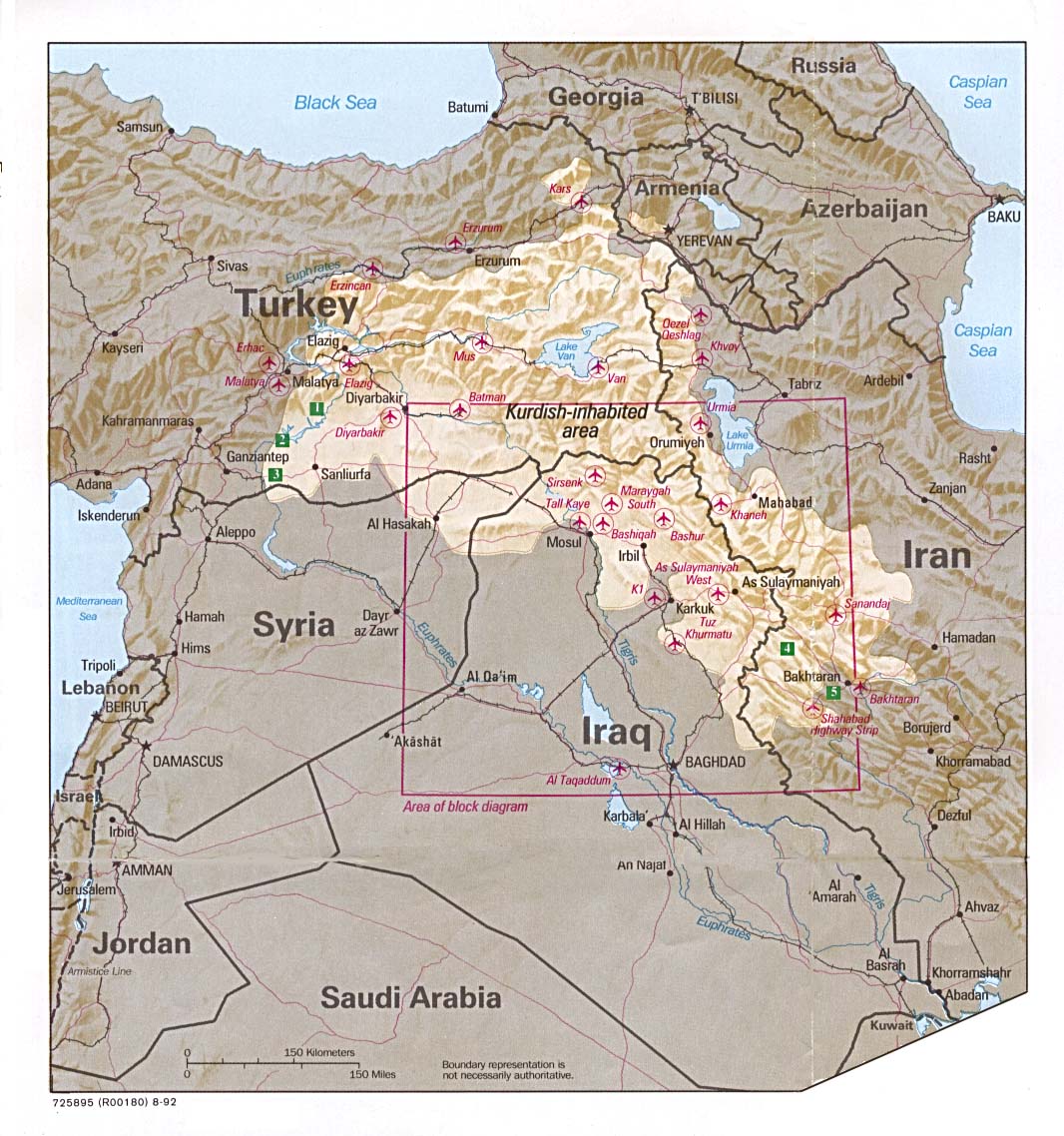
English: Source stated "The following maps were produced by the U.S. Central Intelligence Agency, unless otherwise indicated." The original, non-cropped map also states: "Boundary representation is not necessarily authoritative". |
| Druge wersije toś teje dataje |

.jpg)
Bitte vermeide es Originale zu überschreiben: jede Veränderung, wie etwa Cropping, sollte mit einem neuen Namen hochgeladen werden und das Original im "other versions=" Parameter vermerkt werden, damit die exakte Datei aus den Datenbanken der CIA entsprechend zugeordnet werden kann. Die Metadaten auf dieser Seite wurden direkt aus der Datenbank der CIA importiert; zusätzliche Beschreibungstexte können jederzeit durch Wikimedianer im "description=" Parameter hinzugefügt werden.
(Hinweis: Redakteure, die diese Mitteilung veröffentlichen, sind dringend aufgefordert, Details hinzuzufügen und zu erklären, warum der vorstehende Absatz auf diese Datei Anwendung findet.)
Licencěrowanje
| Dieses Bild ist eine Arbeit eines CIA-Mitarbeiters. Als ein Werk der Regierung der Vereinigten Staaten ist dieses Bild in den USA gemeinfrei.
|

|
See also
- File:Kurdish lands 92.jpg - cropped and down-scaled version of same map apparently first uploaded at English wikipedia in 12 May 2003 from [2] and transferred to Commons on 2007-09-08
- Image:Kurdish lands 92 cropped.jpg - apparently cropped on 15 Jun 2003 (see w:en:Talk:Kurdish people/Archive 1) moved to Commons on or before 2006-12-16 but deleted on 9 February 2007 with comment: Superceeded ny Image:Kurdish-inhabited area by CIA (1992).jpg
Stawizny dataje
Tłoc na datum/cas aby tencasna wersija se lodowała.
.jpg&dir=prev)
.jpg&offset=20100807100521)
.jpg&offset=&limit=20)
.jpg&offset=&limit=50)
.jpg&offset=&limit=100)
.jpg&offset=&limit=250)
.jpg&offset=&limit=500)
| datum/cas | Pśeglědowy wobraz | rozměry | Wužywaŕ | Komentar | |
|---|---|---|---|---|---|
| něntejšny | 20. awgusta 2010, 09:47 | | 982x802 (630 kB) | Sv1xv | Reverted to version as of 18:21, 9 February 2007 |
| 19. awgusta 2010, 22:47 |  | 975x795 (177 kB) | Saadwand | Reverted to version as of 10:05, 7 August 2010 | |
| 18. awgusta 2010, 07:15 |  | 975x795 (556 kB) | Kintetsubuffalo | make a new map, stop warring, per discussion | |
| 17. awgusta 2010, 22:51 |  | 975x795 (177 kB) | Daryai | Reverted to version as of 12:55, 14 August 2010 | |
| 14. awgusta 2010, 17:13 |  | 975x795 (556 kB) | Kintetsubuffalo | we're not going to edit war on this-create your own map | |
| 14. awgusta 2010, 14:55 |  | 975x795 (177 kB) | Abuadab | Reverted to version as of 10:05, 7 August 2010 | |
| 13. awgusta 2010, 23:48 |  | 975x795 (556 kB) | Prosfilaes | It's a CIA map as of 1992; if you want to update it, feel free to copy it | |
| 13. awgusta 2010, 22:45 |  | 975x795 (177 kB) | Leosan | Reverted to version as of 10:05, 7 August 2010 | |
| 7. awgusta 2010, 20:14 |  | 975x795 (556 kB) | Kintetsubuffalo | changes fundaments of CIA map for that date. if you want to update, make a new map with a different date | |
| 7. awgusta 2010, 12:05 |  | 975x795 (177 kB) | Saadwand | River coloured. |
Datajowe wužywanje
Slědujucy bok wótkazujo na toś tu dataju:
Globalne wužywanje datajow
Slědujuce druge wikije wužywaju toś ten wobraz:
- Wužywanje na an.wikipedia.org
- Wužywanje na ar.wikipedia.org
- Wužywanje na ar.wikiversity.org
- Wužywanje na ast.wikipedia.org
- Wužywanje na azb.wikipedia.org
- Wužywanje na be.wikipedia.org
- Wužywanje na bn.wikipedia.org
- Wužywanje na br.wikipedia.org
- Wužywanje na ca.wikipedia.org
- Wužywanje na ca.wikinews.org
- Wužywanje na ce.wikipedia.org
- Wužywanje na ckb.wikipedia.org
- Wužywanje na cs.wikipedia.org
- Wužywanje na da.wikipedia.org
- Wužywanje na de.wikipedia.org
- Irak
- Kurden
- Portal:Kurdistan
- Portal:Kurdistan/Willkommen
- Wikipedia:WikiProjekt Kurdistan
- Wikipedia:WikiProjekt Kurdistan/Intro
- Wikipedia:WikiProjekt Kurdistan/Benutzer
- Wikipedia:WikiProjekt Kurdistan/Teilnehmer
- Benutzer:Bohater/ Kurdisch
- Wikipedia:WikiProjekt Kurdistan/Benutzer Box
- Benutzer:Bohater/Spielwiese
- Wikipedia:WikiProjekt Kurdistan/logo
- Benutzer:Projekt-Till/In Memoriam
- Benutzer:Yoda41
- Diskussion:Völkermord an den irakischen Turkmenen
- Wužywanje na el.wikipedia.org
- Wužywanje na en.wikipedia.org
Dalšne globalne wužywanje toś teje dataje pokazaś.
.jpg)
.jpg)