Dataja:Illyrians (English).svg

Seiteninhalte werden in anderen Sprachen nicht unterstützt.
Z Wikipedije

Originalna dataja(dataja SVG, nominalnje: 1.600 × 1.600 piksele, wjelikosć dataje: 5,11 MB)

Toś ta dataja jo z Wikimedia Commons a dajo se pśez druge projekty wužywaś. Wopisanje na jeje boku datajowego wopisanja pokazujo se dołojce.

Zespominanje

wopis
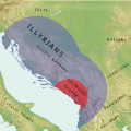
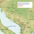
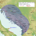
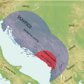
English: Simple Map of Illyrians, Illyria Barbara, Illyria Graeca, Illyrians Proper and Environs
  • carte des tribus illyriennes
  • illyrische Stamme Karte
  • Mappa di tribu illiriche
  • mapa de tribos ilirias
  • Mapa Ilirske plemena
  • mapa de las tribus de Illyrian
  • Fiset ilire harte
  • Χάρτης Ιλλυριών φυλών
  • Карта из иллирийских племен
  • Мапа илирског племена
Datum
Žrědło Swójske źěło
Awtor MaryroseB54
Druge wersije toś teje dataje

[wobźěłaś]

v1
v2
v3
v4
  • The central Balkan tribes in pre-Roman times: Triballi, Autariatae, Dardanians, Scordisci and Moesians by Fanula Papazoglu,1978,ISBN -9025607934
  • The Cambridge Ancient History, Volume 6: The Fourth Century BC by D. M. Lewis (Editor), John Boardman (Editor), Simon Hornblower (Editor), M. Ostwald (Editor),1994,ISBN 0521233488
  • The Cambridge Ancient History, Vol. 10: The Augustan Empire, 43 BC-AD 69 (Volume 10) by Alan Bowman, Edward Champlin, and Andrew Lintott,1996
  • Pannonia and Upper Moesia. A History of the Middle Danube Provinces of the Roman Empire. A Mocsy, S Frere
  • Dalmatia Tome 2 of History of the provinces of the Roman Empire by J. J. Wilkes,1969
  • Wilkes, J. J. The Illyrians, 1992,ISBN 0631198075,
  • Hammond, N. G. L. A History of Greece to 322 B.C., 1986, ISBN-10: 0198730950
  • The Loeb Editor's Notes, 28 Nova Epirus or Illyris Graeca (Epirus, Nova Illyria Graeca) "Nova Epirus or Illyris Graeca extended from the Drilo (Mod. Drina) River on the north to the Ceraunian Mts. on the south, thus comprising a large part of modern Albania. Immediately to the south of it to the Ambracian Gulf (Mod. Gulf of Arta) lay what is here called Old Epirus, approximately identical with the Epirus of modern Greece."
  • Blank map,File:Yugoslavia_topographic_base_map.svg

Licencěrowanje

Ja, awtor tutoho dźěła, wozjewjam je z tym pod slědowacej licencu:
w:dsb:Creative Commons
pśipokazanje źěliś
Smějoš:
  • gromaźe wužywaś – źěło kopěrowaś, rozšyriś a dalej daś
  • změšaś – aby źěło pśiměrił
Pód slědujucymi wuměnjenjami:
  • pśipokazanje – Musyš źěło pó wašni pśipokazaś, kótaruž awtor abo licencowaŕ jo pódał (ale nic pó wašni, až by se gódało, až wón tebje abo twójo wužywanje źěła schwalijo).
  • źěliś – Jolic měnjaš, pśetworjaš toś to źěło abo na njo natwarjaš, móžoš gótowe źěło jano pód teju sameju licencu ako toś ta rozšyriś.
Übersetze diese Datei Diese SVG-Datei enthält eingebetteten Text, der mit jedem geeigneten SVG-Editor, Texteditor oder dem SVG-Übersetzungs-Werkzeug in deine Sprache übersetzt werden kann. Für mehr Informationen siehe Über das Übersetzen von SVG-Dateien.
Bildnotizen
InfoField
Diese Datei ist annotiert: Betrachte diese auf Commons.

Krótkowopisy

Dodaj jednolinkowy wopis tuteje dataje.

W tutej dataji zwobraznjene objekty

motiw górnoserbšćina

tworićel górnoserbšćina

Někajka hódnota bjez zapiska pola Wikidata

status awtorskich prawow górnoserbšćina

19. junija 2016

žórło dataje górnoserbšćina

Stawizny dataje

Tłoc na datum/cas aby tencasna wersija se lodowała.

datum/casPśeglědowy wobrazrozměryWužywaŕKomentar
něntejšny23. junija 2016, 14:56Pśeglědowy wobraz za wersiju wót 23. junija 2016, 14:561.600x1.600 (5,11 MB)MaryroseB54User created page with UploadWizard

Slědujucy bok wótkazujo na toś tu dataju:

Globalne wužywanje datajow

Slědujuce druge wikije wužywaju toś ten wobraz:

Metadaty