
Dataja:Estonian archipelago (Saaremaa and Hiiumaa).jpg
Wuše wótgranicowanje njeeksistěrujo.
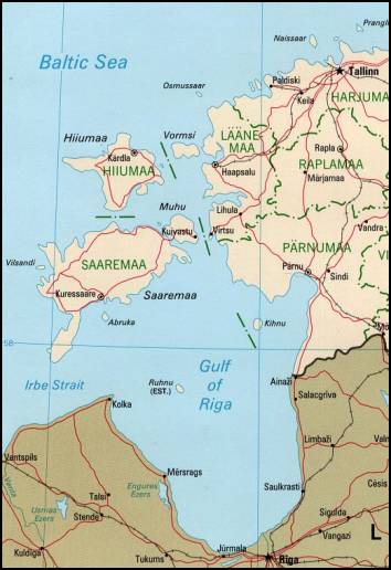
Estonian_archipelago_(Saaremaa_and_Hiiumaa).jpg (354 × 516 pikselow, wjelikosć dataje: 33 kB, MIME-Typ: image/jpeg)
Estonian achipelo (Saarema and Hiiumaa) from en:wiki
This image is an edited version of the original image from the Perry-Castañeda Library Map Collection ([1]) at the University of Texas Libraries. Editing and original upload by en:user:Pascal on en:wiki
See http://www.lib.utexas.edu/maps/europe/estonia_pol99.jpg
The Frequently Asked Questions section indicates that unless otherwise indicated, maps are in the public domain. No such indication for this image.

|
Dieses Bild des Typs Map sollte als Vektorgrafik im SVG-Format neu erstellt werden. Vektorformate haben zahlreiche Vorteile; weitere Information unter Commons:Media for cleanup. Wenn dir eine SVG-Version dieses Bildes vorliegt, so lade diese bitte hoch. Nach dem Hochladen der Datei ist diese Vorlage auf der aktuellen Bildbeschreibungsseite durch die Vorlage {{Vector version available}}, oder kürzer {{Vva}}, zu ersetzen. Es ist empfohlen die neue SVG-Datei „Estonian archipelago (Saaremaa and Hiiumaa).svg“ zu nennen – dann benötigt die Vorlage vector version available (bzw. vva) keinen Parameter.
|


| Dieses Werk wurde von seinem Urheber Perry-Castañeda Library als gemeinfrei veröffentlicht. Dies gilt weltweit. W někotrych krajach je to snano prawnisce njemóžno; jeli tomu tak je: Perry-Castañeda Library gewährt jedem das bedingungslose Recht, dieses Werk für jedweden Zweck zu nutzen, es sei denn, Bedingungen sind gesetzlich erforderlich.
|
_(cropped_230x260).jpg)
.jpg)
Stawizny dataje
Tłoc na datum/cas aby tencasna wersija se lodowała.
| datum/cas | Pśeglědowy wobraz | rozměry | Wužywaŕ | Komentar | |
|---|---|---|---|---|---|
| něntejšny | 18. apryla 2007, 20:55 | | 354x516 (33 kB) | Tene~commonswiki | Reverted to earlier revision |
| 18. apryla 2007, 20:52 |  | 354x516 (33 kB) | Tene~commonswiki | {{Information |Description=Map Of Estonian archipelago (Saaremaa and Hiiumaa) from http://www.lib.utexas.edu/maps/europe/estonia_pol99.jpg See talk page for copyright explanation. Quote... "Most of the maps scanned by the University of Texas Libraries | |
| 20. měrca 2005, 21:05 |  | 354x516 (33 kB) | Laurens~commonswiki | Estonian achipelo (Saarema and Hiiumaa) from en:wiki |
Datajowe wužywanje
Globalne wužywanje datajow
Slědujuce druge wikije wužywaju toś ten wobraz:
- Wužywanje na af.wikipedia.org
- Wužywanje na ar.wikipedia.org
- Wužywanje na arz.wikipedia.org
- Wužywanje na avk.wikipedia.org
- Wužywanje na az.wikipedia.org
- Wužywanje na az.wiktionary.org
- Wužywanje na be-tarask.wikipedia.org
- Wužywanje na bg.wikipedia.org
- Wužywanje na bn.wikipedia.org
- Wužywanje na br.wikipedia.org
- Wužywanje na ca.wikipedia.org
- Wužywanje na ceb.wikipedia.org
- Wužywanje na cs.wikipedia.org
- Wužywanje na cy.wikipedia.org
- Wužywanje na da.wikipedia.org
- Wužywanje na de.wikipedia.org
- Wužywanje na el.wikipedia.org
- Wužywanje na en.wikipedia.org
- Wužywanje na en.wikivoyage.org
- Wužywanje na eo.wikipedia.org
Dalšne globalne wužywanje toś teje dataje pokazaś.
.jpg)
.jpg)