
Dataja:Easter Island map-de.svg

Größe der PNG-Vorschau dieser SVG-Datei: 800 × 569 pikselow. Druge rozeznaśa: 320 × 228 pikselow | 640 × 455 pikselow | 1.024 × 729 pikselow | 1.280 × 911 pikselow | 2.560 × 1.821 pikselow | 1.750 × 1.245 pikselow.
Originalna dataja (dataja SVG, nominalnje: 1.750 × 1.245 piksele, wjelikosć dataje: 856 kB)
Zespominanje
| wopis |
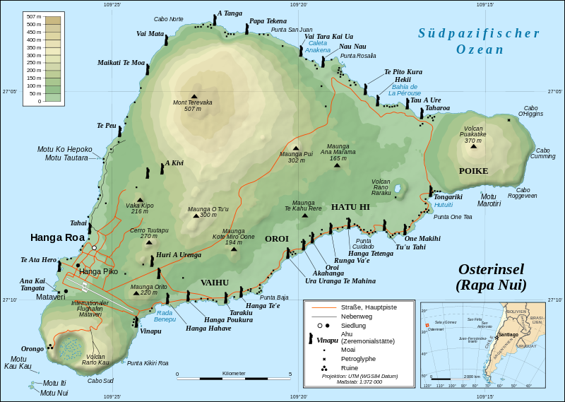
Deutsch: Topografische Karte der Osterinsel, deutsche Version
English: Detailed topographic map in German of Easter Island
Français : Carte topographique détaillée en allemand de l'île de Paques |
| Datum | |
| Žrědło |
Own work, translation of Image:Easter Island map-fr.svg Background and elevation reference maps: topographic map (IGM map ?) and CIA map Ahu names (ceremonial platforms with moai): prof. William Mulloy's map (easier to read here) and [1] Locator reference map: National Geographic |
| Awtor | Sting, translated by Titus Groan |
| Dowolenje (dalewužiwanje tuteje dataje) |
Creative Commons: share alike - attribution required |
| Druge wersije toś teje dataje |
[]
|


![[1]](http://www.waymarker.co.uk/ml/rapanui/map.jpg)
Tuta wektorska grafika je so z Inkscape zdźěłała .

|
Diese SVG-Datei enthält eingebetteten Text, der mit jedem geeigneten SVG-Editor, Texteditor oder dem SVG-Übersetzungs-Werkzeug in deine Sprache übersetzt werden kann. Für mehr Informationen siehe Über das Übersetzen von SVG-Dateien. |
Licencěrowanje
Ja, awtor tutoho dźěła, wozjewjam je z tym pod slědowacej licencu:
Toś ta dataja jo pód licencu Creative Commons Attribution-Share Alike 2.5 Generic licencěrowana
- Smějoš:
- gromaźe wužywaś – źěło kopěrowaś, rozšyriś a dalej daś
- změšaś – aby źěło pśiměrił
- Pód slědujucymi wuměnjenjami:
- pśipokazanje – Musyš źěło pó wašni pśipokazaś, kótaruž awtor abo licencowaŕ jo pódał (ale nic pó wašni, až by se gódało, až wón tebje abo twójo wužywanje źěła schwalijo).
- źěliś – Jolic měnjaš, pśetworjaš toś to źěło abo na njo natwarjaš, móžoš gótowe źěło jano pód teju sameju licencu ako toś ta rozšyriś.
Stawizny dataje
Tłoc na datum/cas aby tencasna wersija se lodowała.
| datum/cas | Pśeglědowy wobraz | rozměry | Wužywaŕ | Komentar | |
|---|---|---|---|---|---|
| něntejšny | 2. oktobra 2012, 18:31 | | 1.750x1.245 (856 kB) | NordNordWest | update |
| 14. maja 2008, 19:24 |  | 1.750x1.245 (536 kB) | NordNordWest | {{Assessments|com=1}} {{Information| |Description= {{de|Topografische Karte der Osterinsel, deutsche Version}} {{en|Detailed topographic map in German of Easter Island}} {{fr|Carte topographique détaillée en alle |
Datajowe wužywanje
Slědujucy bok wótkazujo na toś tu dataju:
Globalne wužywanje datajow
Slědujuce druge wikije wužywaju toś ten wobraz:
- Wužywanje na als.wikipedia.org
- Wužywanje na de.wikipedia.org
- Wužywanje na de.wiktionary.org
- Wužywanje na hsb.wikipedia.org
- Wužywanje na it.wiktionary.org
- Wužywanje na mn.wikipedia.org
- Wužywanje na tpi.wikipedia.org