
Dataja:As-map.png
Wuše wótgranicowanje njeeksistěrujo.
As-map.png (329 × 353 pikselow, wjelikosć dataje: 21 kB, MIME-Typ: image/png)

|
Dieses Bild des Typs Map sollte als Vektorgrafik im SVG-Format neu erstellt werden. Vektorformate haben zahlreiche Vorteile; weitere Information unter Commons:Media for cleanup. Wenn dir eine SVG-Version dieses Bildes vorliegt, so lade diese bitte hoch. Nach dem Hochladen der Datei ist diese Vorlage auf der aktuellen Bildbeschreibungsseite durch die Vorlage {{Vector version available}}, oder kürzer {{Vva}}, zu ersetzen. Es ist empfohlen die neue SVG-Datei „As-map.svg“ zu nennen – dann benötigt die Vorlage vector version available (bzw. vva) keinen Parameter.
|
Zespominanje
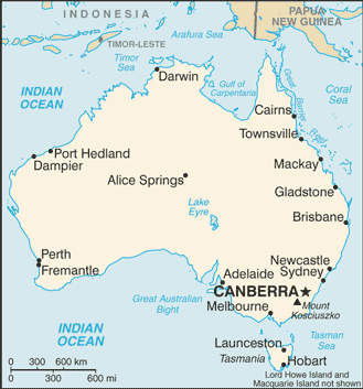
| wopis |
Lëtzebuergesch: Kaart vun Australien. |
| Datum | 19. julija 2007 |
| Žrědło |
CIA World Factbook |
| Awtor | United States Central Intelligence Agency |
| Druge wersije toś teje dataje |
|
.png)
Licencěrowanje
Dieses Werk ist gemeinfrei, weil es Bildmaterial aus dem CIA World Factbook darstellt, das ursprünglich vom Zentralen Nachrichtendienst der Vereinigten Staaten veröffentlicht wurde.
|
 |
Stawizny dataje
Tłoc na datum/cas aby tencasna wersija se lodowała.
| datum/cas | Pśeglědowy wobraz | rozměry | Wužywaŕ | Komentar | |
|---|---|---|---|---|---|
| něntejšny | 28. januara 2009, 18:48 | | 329x353 (21 kB) | DaniDF1995 | Reverted to version as of 16:48, 28 January 2009 |
| 28. januara 2009, 18:48 |  | 329x386 (20 kB) | DaniDF1995 | Some fix | |
| 28. januara 2009, 18:48 |  | 329x353 (21 kB) | DaniDF1995 | Reverted to version as of 16:46, 28 January 2009 | |
| 28. januara 2009, 18:47 |  | 329x386 (20 kB) | DaniDF1995 | Some fix | |
| 28. januara 2009, 18:46 |  | 329x353 (21 kB) | DaniDF1995 | Reverted to version as of 09:57, 25 July 2007 | |
| 28. januara 2009, 18:45 |  | 329x386 (20 kB) | DaniDF1995 | Some fix | |
| 25. julija 2007, 11:57 |  | 329x353 (21 kB) | Hoshie | Updated map of Australia from the CIA World Factbook, 19 July 07 rev. Src: https://www.cia.gov/library/publications/the-world-factbook/maps/as-map.gif | |
| 26. februara 2005, 17:07 |  | 328x352 (13 kB) | Alfio | CIA map of Australia |
Datajowe wužywanje
Slědujucy bok wótkazujo na toś tu dataju:
Globalne wužywanje datajow
Slědujuce druge wikije wužywaju toś ten wobraz:
- Wužywanje na ab.wikipedia.org
- Wužywanje na af.wikipedia.org
- Wužywanje na arz.wikipedia.org
- Wužywanje na azb.wikipedia.org
- Wužywanje na bbc.wikipedia.org
- Wužywanje na bg.wikipedia.org
- Wužywanje na bh.wikipedia.org
- Wužywanje na bjn.wikipedia.org
- Wužywanje na bn.wikipedia.org
- Wužywanje na ca.wikipedia.org
- Wužywanje na ckb.wikipedia.org
- Wužywanje na cs.wikipedia.org
- Wužywanje na cv.wikipedia.org
- Wužywanje na da.wikipedia.org
- Wužywanje na de.wikinews.org
- Wužywanje na dty.wikipedia.org
- Wužywanje na en.wikipedia.org
- List of cities in Australia
- Wikipedia talk:WikiProject Countries/Proposal 1
- Trans Australia Airlines Flight 538
- User:Peursem
- Outline of Australia
- Wikipedia:Recent additions/2004/April
- Module:Location map/data/Australia/doc
- User talk:Nil Einne
- Module:Location map/data/Australia
- North Australian Basin
- Wužywanje na en.wikibooks.org
- Wužywanje na en.wikinews.org
- Wužywanje na eo.wikipedia.org
- Wužywanje na es.wikipedia.org
- Wužywanje na fa.wikipedia.org
- Wužywanje na fi.wikipedia.org
- Wužywanje na fi.wikinews.org
- Wužywanje na fo.wikipedia.org
- Wužywanje na fr.wikipedia.org
Dalšne globalne wužywanje toś teje dataje pokazaś.