Dataja:Viking expansion.png

Seiteninhalte werden in anderen Sprachen nicht unterstützt.
Z Wikipedije

Viking_expansion.png(507 × 310 pikselow, wjelikosć dataje: 109 kB, MIME-Typ: image/png)

Toś ta dataja jo z Wikimedia Commons a dajo se pśez druge projekty wužywaś. Wopisanje na jeje boku datajowego wopisanja pokazujo se dołojce.

(see en:File talk:Viking Expansion.svg)

Zespominanje

wopis
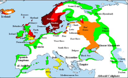
English: Map showing area of Scandinavian settlement (Vikings and Normans descendants from Normandy) in
 
eighth century
 
ninth century
 
tenth century
 
eleventh century
 
denotes areas subjected to frequent Scandinavian contacts, but with little or no Scandinavian settlement
Datum 14. nowembra 2006 (Original-Hochladedatum)
Žrědło Briangotts (original uploader)
Awtor Briangotts (original uploader)
Dowolenje
(dalewužiwanje tuteje dataje)
Ja, awtor tutoho dźěła, wozjewjam je z tym pod slědowacymi licencami:
GNU head Směće tutón dokument pod wuměnjenjemi licency GNU Free Documentation License, wersija 1.2 abo nowša wersija, wozjewjeneje wot załožby Free Software Foundation kopěrować, rozšěrjeć a/abo změnić; njejsu njezměnite wotrězki, njeje žadyn prědni a žadyn zadni wobalkowy tekst. Kopija licency je we wotrězku z titulom GNU Free Documentation License wobsahowana.
w:dsb:Creative Commons
pśipokazanje źěliś
Toś ta dataja jo pód licencu Creative Commons Attribution-Share Alike 3.0 Unported licencěrowana
Smějoš:
  • gromaźe wužywaś – źěło kopěrowaś, rozšyriś a dalej daś
  • změšaś – aby źěło pśiměrił
Pód slědujucymi wuměnjenjami:
  • pśipokazanje – Musyš źěło pó wašni pśipokazaś, kótaruž awtor abo licencowaŕ jo pódał (ale nic pó wašni, až by se gódało, až wón tebje abo twójo wužywanje źěła schwalijo).
  • źěliś – Jolic měnjaš, pśetworjaš toś to źěło abo na njo natwarjaš, móžoš gótowe źěło jano pód teju sameju licencu ako toś ta rozšyriś.
Tuta licencna marka je so tutej dataji jako dźěl licencneje aktualizacije přidała.
Móžoš licencu swójeje wólby wubraś.
Druge wersije toś teje dataje

[wobźěłaś]

File:Viking Expansion.svg ist eine vektorisierte Version dieses Bildes. Diese sollte an Stelle des Rasterbildes verwendet werden, sofern sie nicht schlechter ist.

File:Viking expansion.png → File:Viking Expansion.svg

Für weitere Informationen siehe Help:SVG.

In anderen Sprachen
Alemannisch  Bahasa Indonesia  Bahasa Melayu  British English  català  čeština  dansk  Deutsch  eesti  English  español  Esperanto  euskara  français  Frysk  galego  hrvatski  Ido  italiano  lietuvių  magyar  Nederlands  norsk bokmål  norsk nynorsk  occitan  Plattdüütsch  polski  português  português do Brasil  română  Scots  sicilianu  slovenčina  slovenščina  suomi  svenska  Tiếng Việt  Türkçe  vèneto  Ελληνικά  беларуская (тарашкевіца)  български  македонски  нохчийн  русский  српски / srpski  татарча/tatarça  українська  ქართული  հայերեն  বাংলা  தமிழ்  മലയാളം  ไทย  한국어  日本語  简体中文  繁體中文  עברית  العربية  فارسی  +/−
Neue Vektorgrafik

Krótkowopisy

Dodaj jednolinkowy wopis tuteje dataje.

W tutej dataji zwobraznjene objekty

motiw górnoserbšćina

status awtorskich prawow górnoserbšćina

14. nowembra 2006

MIME-Typ nimšćina

image/png

Stawizny dataje

Tłoc na datum/cas aby tencasna wersija se lodowała.

(nejnowše | nejstarše) (nowšych 10 | ) (10 | 20 | 50 | 100 | 250 | 500) pokazaś
datum/casPśeglědowy wobrazrozměryWužywaŕKomentar
něntejšny26. februara 2018, 00:58Pśeglědowy wobraz za wersiju wót 26. februara 2018, 00:58507x310 (109 kB)AsmodimAdded the territory of the Norman "Kingdom of Africa (see the wikipedia article), conquests of the Norman kingdom of Sicily under Roger II
5. awgusta 2016, 20:10Pśeglědowy wobraz za wersiju wót 5. awgusta 2016, 20:10507x310 (109 kB)TheutatisExpanded area in Italy according to Norman expansion.
17. julija 2008, 12:52Pśeglědowy wobraz za wersiju wót 17. julija 2008, 12:52800x310 (140 kB)F7~commonswiki
15. maja 2007, 23:14Pśeglědowy wobraz za wersiju wót 15. maja 2007, 23:141.464x568 (51 kB)Briangotts== Summary == {{Information |Description= Map showing area of Scandinavian settlement in<br> {{legend|#800000|eighth centuries}} {{legend|#f00|ninth centuries}} {{legend|#ff8000|tenth centuries}} {{legend|#eded00|eleventh centuries}} {{legend|#0f0|denotes
10. maja 2007, 15:58Pśeglědowy wobraz za wersiju wót 10. maja 2007, 15:581.464x568 (51 kB)Briangotts== Summary == {{Information |Description= Map showing area of Scandinavian settlement in<br> {{legend|#800000|eighth century}} {{legend|#f00|ninth century}} {{legend|#ff8000|tenth century}} {{legend|#eded00|eleventh century}} {{legend|#0f0|denotes areas s
16. apryla 2007, 21:56Pśeglědowy wobraz za wersiju wót 16. apryla 2007, 21:561.464x568 (33 kB)Tene~commonswikiOptimised (0)
23. februara 2007, 13:43Pśeglědowy wobraz za wersiju wót 23. februara 2007, 13:431.464x568 (79 kB)Dbachmann"yellow"
23. februara 2007, 13:33Pśeglědowy wobraz za wersiju wót 23. februara 2007, 13:331.464x568 (80 kB)Dbachmanncropped, fiddled with Iceland.
2. februara 2007, 20:58Pśeglědowy wobraz za wersiju wót 2. februara 2007, 20:581.838x710 (62 kB)Tene~commonswikiOptimised (0)
20. januara 2007, 14:50Pśeglědowy wobraz za wersiju wót 20. januara 2007, 14:501.838x710 (110 kB)Liftarn{{Information |Description=Map showing area of Scandinavian settlement in the eighth (dark red), ninth (red), tenth (orange) and eleventh (yellow) centuries. Green denotes areas subjected to frequent en:Viking raids. [[:e
(nejnowše | nejstarše) (nowšych 10 | ) (10 | 20 | 50 | 100 | 250 | 500) pokazaś

Žedne boki njewótkazuju na toś tu dataju.

Globalne wužywanje datajow

Slědujuce druge wikije wužywaju toś ten wobraz:

Metadaty