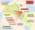
Dataja:Umgriffe Kurdistans.png

Wjelikosć toś togo pśeglěda: 713 × 600 pikselow. Druge rozeznaśa: 285 × 240 pikselow | 571 × 480 pikselow | 913 × 768 pikselow | 1.217 × 1.024 pikselow | 1.349 × 1.135 pikselow.
Originalna dataja (1.349 × 1.135 pikselow, wjelikosć dataje: 320 kB, MIME-Typ: image/png)
Stawizny dataje
Tłoc na datum/cas aby tencasna wersija se lodowała.
| datum/cas | Pśeglědowy wobraz | rozměry | Wužywaŕ | Komentar | |
|---|---|---|---|---|---|
| něntejšny | 3. januara 2013, 17:11 |  | 1.349x1.135 (320 kB) | Kopiersperre | OptiPNG |
| 24. oktobra 2009, 18:14 |  | 1.349x1.135 (467 kB) | Chumwa | Dohuk und Sulaimaniyya ergänzt | |
| 20. oktobra 2009, 07:25 |  | 1.349x1.135 (466 kB) | Chumwa | Diyarbakır ergänzt und Lage Malatyas korrigiert | |
| 19. oktobra 2009, 07:26 |  | 1.349x1.135 (461 kB) | Chumwa | Hinweis "2005 vom Irak anerkannt" bei der Autonomen Region Kurdistan im Irak entfernt, Staatengrenzen besser nachverfolgbar gestaltet, Beschriftungen Nordkurdisten, Ostkurdistan und Südkurdistan sowie ein paar Ortspunkte ergänzt | |
| 17. oktobra 2009, 11:04 |  | 1.349x1.135 (416 kB) | Chumwa | kleinere Korrekturen | |
| 17. oktobra 2009, 09:07 |  | 1.349x1.135 (415 kB) | Chumwa | Karte weiter ausgebaut | |
| 15. oktobra 2009, 23:28 |  | 1.350x1.210 (291 kB) | Chumwa | {{Information |Description= {{ de }} Kurdische Gebiete und Gebietsansprüche im Laufe der Geschichte |Source={{self}} |Date=2009-10 |Author= Maximilian Dörrbecker (Chumwa) |Permission={{self|cc-by-sa-2.5}} Sie dür |
Datajowe wužywanje
Slědujucy bok wótkazujo na toś tu dataju:
Globalne wužywanje datajow
Slědujuce druge wikije wužywaju toś ten wobraz:
- Wužywanje na de.wikipedia.org
- Kurdistan
- Benutzer:Chumwa
- Diskussion:Nemrut Dağı (Adıyaman)
- Wikipedia:Kartenwerkstatt/Archiv/2009-10
- Benutzer:Kopiersperre/Westermann Orient
- Kurdische Staatsgründungsbestrebungen
- Wikipedia:Kartenwerkstatt/Karte des Tages/Galerie
- Diskussion:Kobanê
- Benutzer:Chumwa/SomeOfMyFiles
- Benutzer Diskussion:Chumwa/Archiv/2017/3. Quartal
- Wužywanje na de.wiktionary.org
- Wužywanje na en.wikipedia.org
- Wužywanje na la.wikipedia.org
- Wužywanje na sv.wikipedia.org
