
Dataja:SevenYearsWar.png

Wjelikosć toś togo pśeglěda: 800 × 370 pikselow. Drugej rozeznaśi: 320 × 148 pikselow | 640 × 296 pikselow | 1.357 × 628 pikselow.
Originalna dataja (1.357 × 628 pikselow, wjelikosć dataje: 41 kB, MIME-Typ: image/png)

|
Dieses Bild des Typs Military map sollte als Vektorgrafik im SVG-Format neu erstellt werden. Vektorformate haben zahlreiche Vorteile; weitere Information unter Commons:Media for cleanup. Wenn dir eine SVG-Version dieses Bildes vorliegt, so lade diese bitte hoch. Nach dem Hochladen der Datei ist diese Vorlage auf der aktuellen Bildbeschreibungsseite durch die Vorlage {{Vector version available}}, oder kürzer {{Vva}}, zu ersetzen. Es ist empfohlen die neue SVG-Datei „SevenYearsWar.svg“ zu nennen – dann benötigt die Vorlage vector version available (bzw. vva) keinen Parameter.
|
Zespominanje
| wopis |
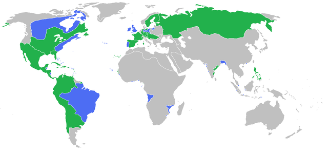
English: Locator map of the competing sides of the Seven Years War before outset of the war (mid-1750s). Blue: Great Britain, Portugal with more. Green: France, Spain with more. Great Britain, Prussia, Portugal, with allies
France, Spain, Austria, Russia, Sweden with allies Français : Carte montrant les forces en présence lors de la guerre de Sept Ans (milieu des années 1750).
Grande Bretagne, Prusse, Portugal, leurs alliés et dépendances
France, Espagne, Autriche, Russie, Suède, leurs alliés et dépendances (Partially based on Atlas of World History (2007) - There was also a treaty in 1783, Imperialism and Revolutions, map) |
| Datum | |
| Žrědło | Swójske źěło |
| Awtor | Gabagool |
Licencěrowanje
Ja, awtor tutoho dźěła, wozjewjam je z tym pod slědowacej licencu:
Toś ta dataja jo pód licencu Creative Commons Attribution 3.0 Unported licencěrowana
- Smějoš:
- gromaźe wužywaś – źěło kopěrowaś, rozšyriś a dalej daś
- změšaś – aby źěło pśiměrił
- Pód slědujucymi wuměnjenjami:
- pśipokazanje – Musyš źěło pó wašni pśipokazaś, kótaruž awtor abo licencowaŕ jo pódał (ale nic pó wašni, až by se gódało, až wón tebje abo twójo wužywanje źěła schwalijo).
Stawizny dataje
Tłoc na datum/cas aby tencasna wersija se lodowała.
| datum/cas | Pśeglědowy wobraz | rozměry | Wužywaŕ | Komentar | |
|---|---|---|---|---|---|
| něntejšny | 23. junija 2009, 17:54 | | 1.357x628 (41 kB) | Gabagool | corrected India more appropriatly |
| 11. junija 2009, 15:59 |  | 1.357x628 (41 kB) | Gabagool | some fixes | |
| 11. junija 2009, 13:16 |  | 1.357x628 (41 kB) | Gabagool | more details in Germany | |
| 7. junija 2009, 00:20 |  | 1.357x628 (41 kB) | Gabagool | {{Information |Description={{en|1=Locator map of the competing sides of the Seven Years War before outset of the war (early 1750s).<br> Blue: Great Britain, Portugal with more. Green: France, Spain with more. Light green: French largest expansion in India |
Datajowe wužywanje
Slědujucy bok wótkazujo na toś tu dataju:
Globalne wužywanje datajow
Slědujuce druge wikije wužywaju toś ten wobraz:
- Wužywanje na af.wikipedia.org
- Wužywanje na als.wikipedia.org
- Wužywanje na an.wikipedia.org
- Wužywanje na ar.wikipedia.org
- Wužywanje na arz.wikipedia.org
- Wužywanje na ast.wikipedia.org
- Wužywanje na az.wikipedia.org
- Wužywanje na ba.wikipedia.org
- Wužywanje na bg.wikipedia.org
- Wužywanje na bn.wikipedia.org
- Wužywanje na br.wikipedia.org
- Wužywanje na bs.wikipedia.org
- Wužywanje na ca.wikipedia.org
- Wužywanje na cs.wikipedia.org
- Wužywanje na da.wikipedia.org
- Wužywanje na de.wikipedia.org
- Wužywanje na en.wikipedia.org
- Wužywanje na eo.wikipedia.org
- Wužywanje na es.wikipedia.org
- Wužywanje na fa.wikipedia.org
- Wužywanje na fi.wikipedia.org
- Wužywanje na fr.wikipedia.org
- Wužywanje na ga.wikipedia.org
- Wužywanje na he.wikipedia.org
- Wužywanje na hi.wikipedia.org
- Wužywanje na hsb.wikipedia.org
- Wužywanje na is.wikipedia.org
- Wužywanje na it.wikipedia.org
- Wužywanje na ja.wikipedia.org
- Wužywanje na ko.wikipedia.org
- Wužywanje na lt.wikipedia.org
- Wužywanje na lv.wikipedia.org
- Wužywanje na ml.wikipedia.org
Dalšne globalne wužywanje toś teje dataje pokazaś.