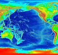
Dataja:Pacific elevation.jpg

Wjelikosć toś togo pśeglěda: 632 × 599 pikselow. Druge rozeznaśa: 253 × 240 pikselow | 506 × 480 pikselow | 810 × 768 pikselow | 1.080 × 1.024 pikselow | 2.500 × 2.370 pikselow.
Originalna dataja (2.500 × 2.370 pikselow, wjelikosć dataje: 899 kB, MIME-Typ: image/jpeg)
Stawizny dataje
Tłoc na datum/cas aby tencasna wersija se lodowała.
| datum/cas | Pśeglědowy wobraz | rozměry | Wužywaŕ | Komentar | |
|---|---|---|---|---|---|
| něntejšny | 7. měrca 2006, 05:41 |  | 2.500x2.370 (899 kB) | Interiot~commonswiki | Elevation of the Pacific ocean Source: http://www.ngdc.noaa.gov/mgg/image/2minrelief.html |
Datajowe wužywanje
Slědujucy bok wótkazujo na toś tu dataju:
Globalne wužywanje datajow
Slědujuce druge wikije wužywaju toś ten wobraz:
- Wužywanje na als.wikipedia.org
- Wužywanje na ang.wikipedia.org
- Wužywanje na ar.wikipedia.org
- Wužywanje na avk.wikipedia.org
- Wužywanje na azb.wikipedia.org
- Wužywanje na az.wikipedia.org
- Wužywanje na bat-smg.wikipedia.org
- Wužywanje na be.wikipedia.org
- Wužywanje na bg.wikipedia.org
- Wužywanje na bn.wikipedia.org
- Wužywanje na bs.wikipedia.org
- Wužywanje na ca.wikipedia.org
- Wužywanje na ceb.wikipedia.org
- Wužywanje na chr.wikipedia.org
- Wužywanje na crh.wikipedia.org
- Wužywanje na cs.wikipedia.org
- Wužywanje na da.wikipedia.org
- Wužywanje na de.wikipedia.org
- Wužywanje na de.wiktionary.org
- Wužywanje na en.wikipedia.org
- Wužywanje na en.wikibooks.org
- Wužywanje na es.wikipedia.org
- Wužywanje na et.wikipedia.org
- Wužywanje na ext.wikipedia.org
- Wužywanje na fa.wikipedia.org
- Wužywanje na fiu-vro.wikipedia.org
- Wužywanje na fi.wikipedia.org
- Wužywanje na fj.wikipedia.org
- Wužywanje na frr.wikipedia.org
- Wužywanje na fy.wikipedia.org
- Wužywanje na gan.wikipedia.org
- Wužywanje na gd.wikipedia.org
- Wužywanje na gl.wikipedia.org
- Wužywanje na he.wikipedia.org
- Wužywanje na hif.wikipedia.org
- Wužywanje na hr.wikipedia.org
- Wužywanje na hsb.wikipedia.org
- Wužywanje na hu.wikipedia.org
Dalšne globalne wužywanje toś teje dataje pokazaś.

