
Dataja:LocationRomania.png
Wuše wótgranicowanje njeeksistěrujo.
LocationRomania.png (250 × 115 pikselow, wjelikosć dataje: 7 kB, MIME-Typ: image/png)

|
Dieses Bild des Typs Locator map sollte als Vektorgrafik im SVG-Format neu erstellt werden. Vektorformate haben zahlreiche Vorteile; weitere Information unter Commons:Media for cleanup. Wenn dir eine SVG-Version dieses Bildes vorliegt, so lade diese bitte hoch. Nach dem Hochladen der Datei ist diese Vorlage auf der aktuellen Bildbeschreibungsseite durch die Vorlage {{Vector version available}}, oder kürzer {{Vva}}, zu ersetzen. Es ist empfohlen die neue SVG-Datei „LocationRomania.svg“ zu nennen – dann benötigt die Vorlage vector version available (bzw. vva) keinen Parameter.
|
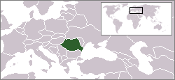
English: Location map of Romania.
Originally created for English Wikipedia by Vardion.
| |
Dieses Werk wurde (oder wird hiermit) durch den Autor, Vardion auf Wikimedia Commons , in die Gemeinfreiheit übergeben. Dies gilt weltweit. Falls dies rechtlich nicht möglich ist: |
Stawizny dataje
Tłoc na datum/cas aby tencasna wersija se lodowała.
| datum/cas | Pśeglědowy wobraz | rozměry | Wužywaŕ | Komentar | |
|---|---|---|---|---|---|
| něntejšny | 2. apryla 2009, 22:45 | | 250x115 (7 kB) | D.h | Reverted to version as of 20:37, 2 April 2009 |
| 2. apryla 2009, 22:37 |  | 250x115 (6 kB) | D.h | Reverted to version as of 23:25, 6 July 2007 | |
| 2. apryla 2009, 22:37 |  | 250x115 (7 kB) | D.h | Reverted to version as of 20:22, 8 September 2007 | |
| 1. měrca 2009, 04:02 |  | 1.600x1.200 (470 kB) | Olahus | Romania in EU | |
| 8. septembra 2007, 22:22 |  | 250x115 (7 kB) | Skatefreak | Reverted to version as of 11:48, 4 June 2006 | |
| 7. julija 2007, 01:25 |  | 250x115 (6 kB) | Dove | Location of the Romania {{GFDL}} Category:Locator maps for former territories | |
| 4. junija 2006, 13:48 |  | 250x115 (7 kB) | Rain74 | added Serbia-Montenegro border | |
| 9. decembra 2004, 17:08 |  | 250x115 (7 kB) | EugeneZelenko | Location map for the Romania.<br/>Originally created for English Wikipedia by Vardion.<br/>{{PD}}<br/>Category:Country locator maps |
Datajowe wužywanje
Slědujucy bok wótkazujo na toś tu dataju:
Globalne wužywanje datajow
Slědujuce druge wikije wužywaju toś ten wobraz:
- Wužywanje na arc.wikipedia.org
- Wužywanje na av.wikipedia.org
- Wužywanje na bg.wikipedia.org
- Wužywanje na bo.wikipedia.org
- Wužywanje na bpy.wikipedia.org
- Wužywanje na br.wikipedia.org
- Wužywanje na bs.wikiquote.org
- Wužywanje na ca.wikipedia.org
- Wužywanje na ckb.wikipedia.org
- Wužywanje na de.wikinews.org
- Wužywanje na el.wiktionary.org
- Wužywanje na en.wikipedia.org
- Wužywanje na en.wikinews.org
- Wužywanje na en.wikivoyage.org
- Wužywanje na en.wiktionary.org
- Wužywanje na es.wikinews.org
- Wužywanje na eu.wiktionary.org
- Wužywanje na fiu-vro.wikipedia.org
- Wužywanje na fr.wikinews.org
- Wužywanje na gu.wikipedia.org
- Wužywanje na he.wikivoyage.org
- Wužywanje na hu.wikipedia.org
- Wužywanje na hu.wikinews.org
- Wužywanje na ia.wikipedia.org
- Wužywanje na incubator.wikimedia.org
- Wužywanje na ja.wikinews.org
Dalšne globalne wužywanje toś teje dataje pokazaś.